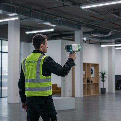
Launched as “the first handheld dynamic laser scanning tool made for professionals”, the NavVis MLX focuses on data quality, portability, and user comfort. It is meant to be used indoors and outdoors, and main applications are AEC and surveying workflows.
Product Features
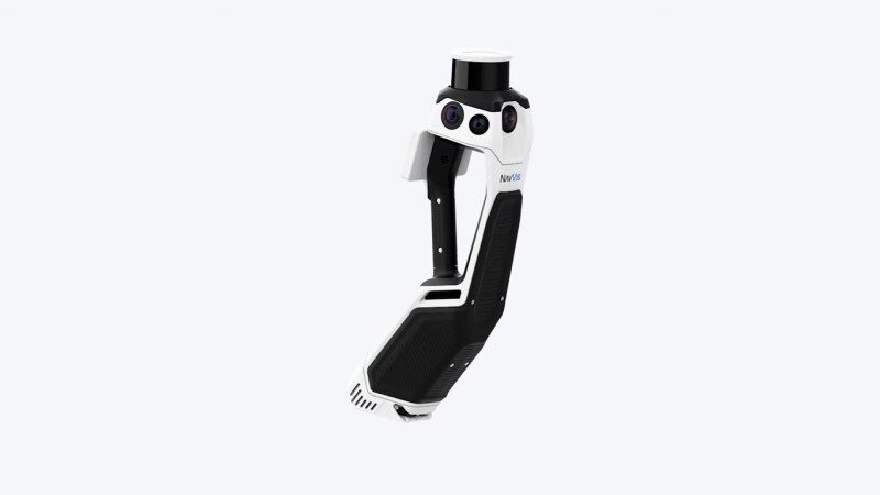
The MLX has a 32-layer class-1 Lidar sensor that emits 640,000 per second and has a 5mm accuracy indoors. Four 12MP cameras enable capturing 270- and 360-degree panoramic images: high-resolution 270º images are captured when the scanner is resting on the harness and 360º images when it is lifted above the head.
Two 2MP cameras for visual odometry augment Lidar SLAM for trajectory and mapping. A capacitive multi-touch display provides real-time visual feedback on the data coverage and SLAM status. Maximum operating time is 45 minutes. Point cloud data output formats include E57, PLY, LAS, PTS, and XYZ. The data captured with the MLX works seamlessly with NavVis IVION point cloud processing software, to provide customers with a digital twin foundation.
For improved data accuracy, the MLX is fully compatible with standard tools in the field and can capture control points (such as checkerboards, nails, scribe marks, and natural features) measured by Total Stations and GNSS rovers. It supports the alignment of datasets and national and global coordinates for geo-registration.
Full flexibility for detailed environmental capture
Typically, handheld laser scanning tools have been limited in their utility due to delivering low-quality data, unergonomic handling, and unreliability. The MLX is a compact device, measuring 60 × 19 × 15 cm, which makes it ideal for confined, smaller spaces or shorter, more frequent scanning on site. It contains a harness system for comfortable extended use, enabling long scans and providing full flexibility for detailed environmental capture. The harness system positions the NavVis MLX stationary, so users don't have to carry it constantly. When needed, it can be easily taken out and moved freely.
In a product announcement video, NavVis’ founders Georg Schroth and Felix Reinshagen explain why they developed a smaller, lighter scanning device. With a weight of 3.6kg including batteries, the MLX is significantly lighter than the VLX3 (8.5kg) and VLX2 (8.7kg). Its smaller size makes it more versatile for scanning narrow indoor spaces.
Sample dataset and video
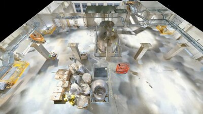
NavVis MLX captured a wide range of spaces within the building and its surroundings, such as complex technical rooms, large spaces with technical complexity, and heavy machinery requiring highly detailed capture. The site also contained empty office spaces of varying sizes, and challenging narrow walkways, indoors and outdoors. A sample of NavVis MLX point cloud data in .e57 format of this site is available for download.
Additional resources
An additional fly-through video showing a 3D mesh made with the same dataset is available on YouTube. More in-depth information about the MLX, including how to set up and use the scanner for the best results, is found on the online NavVis Knowledge Base.