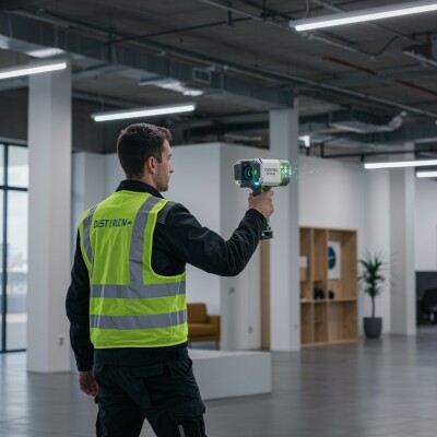
As we noted earlier today, one of the biggest overarching themes from this year’s Intergeo event was the prevalence of handheld mobile mapping systems. As the sensors have been shrunken to the point where they can be held within a handheld system, and SLAM algorithms have allowed the data captured from these sensors to be spatially relevant, the demand of the systems has increased tremendously over the last couple of years. One of the newest examples on the market, NavVis’s MLX scanning system, was on display for users to test out and learn more about at this year’s Intergeo.
Geo Week News was among those who took the chance to learn more about the system in Stuttgart, Germany, getting the opportunity to speak with NavVis Customer Service Manager Morten Hellemann about the system.
One of the big questions most have regarding the MLX is the fact that it comes with straps to go over a user’s shoulders to assist with carrying. In comparison to smaller systems that can be truly handheld, it is a stark difference. Hellemann defends the straps, though, first saying that the 3.5-kilogram system can easily be carried without the straps – Geo Week News held the system and can confirm this – and that it helps to carry the system how we naturally carry things. He demonstrated how we typically hold our phone, for example, and it’s the same arm angle that most take with scanning. That can get tiring over a full project, and having the straps helps distribute the weight through one’s entire body.
Helleman showed off a few other aspects of the MLX to Geo Week News, including the ability to take panoramic pictures with the system. He showed two methods, one getting a full 360-degree panoramic using the MLX’s cameras and holding the system over one’s head, and then the other holding it in a normal position. Here, the MLX takes a 270-degree panoramic to exclude the user, and that portion can be replaced with a colorized point cloud to create a makeshift 360-degree panoramic.
Finally, he showed off some of the user interface that makes the scanning process significantly easier for the end user. First, the on-device screen shows live updates of what has been captured – and to what degree – eliminating the possibility of leaving a project site and discovering a crucial area was missed and re-scanning is necessary. The screen also shows a bar to indicate the strength of SLAM in the current environment.