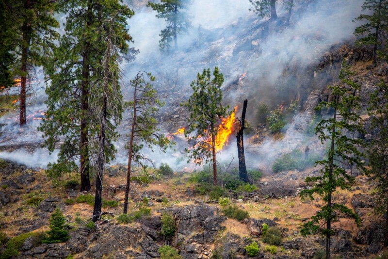
The effects of climate change rear their head in different ways depending on where you are in the world, generally bringing more extreme weather events – both in terms of frequency and intensity. In the western part of North America, along with other places around the world, one of the ways this has manifested is in the form of longer and more intense fire seasons. Just as we’re publishing this in mid-September, a fast-spreading wildfire in Southern California has forced over 10,000 people to evacuate their homes.
There are many ways in which researchers and others are trying to mitigate the effects of climate change and put people out of harm’s way, but the unfortunate reality is that, at least in the medium-term, this is now part of life in certain parts of the country. As more communities are built in traditional wildfire zones, more devastation is being brought to people’s doorsteps. It’s vital that people in these areas are aware of what kind of risk to which their community – and by extension, themselves – may be exposed.
One of the tools that can be used to help spread this awareness is GIS, with its ability to layer crucial data in proper spatial context. This idea led to the creation of two new awareness tools allowing people to know whether or not a certain area is part of a wildland-urban interface, or WUI. Leveraging data from Esri, the United States Fire Administration (USFA) and Federal Emergency Management Agency (FEMA) released this summer their WUI Fire Awareness Explorer and WUI Fire Community Awareness Explorer.
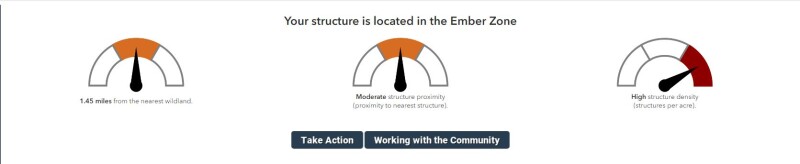
The data pulled together to create these awareness tools is a combination of Sentinel-2 Land Cover Data in ArcGIS Living Atlas of the World and FEMA’s USA Structures Data. In the announcement of these tools from July, they note that the dataset provides “detailed mapping of areas where human activities and wildland vegetation intersect, creating a higher potential for wildfires.”
Geo Week News recently spoke with Dr. Lori Moore-Merrell, the U.S. Fire Administrator, about the tool and some of the goals. Early in the conversation, she makes clear that the awareness explorer is not a fire risk index for communities. While they are able to develop similar kinds of risk indices for wildlands, the necessary data is not available to build one for communities. However, as these wildfire seasons become longer and more intense, it’s important for people to be aware of their area’s general risk and whether or not they are in this WUI.
“What can we do short of having a risk index in that community? How can we inform [communities] about where they live?” Dr. Moore-Merrell said to Geo Week News. “Just information is powerful, knowing that you are vulnerable to fire because this land is fire-prone; it’s burned for hundreds of years. You put communities in the path of fire. We can help people understand so that they can take precaution to put in fire-resistant building materials, to have behaviors that are different because of where they live.”
That really gets to the crux of this tool, just building that awareness for people about the area in which they live and what kind of risks that could open them up to. Articles like this are part of that awareness, but fire departments across the country – particularly in areas susceptible to wildfires – are also trying to educate the public about this tool. It’s one thing to build the tool, but it’s quite another to have people use them. USFA hopes they can leverage their departments to get that word out.
“We have fire departments that are in these WUI areas or service these areas that are aware these tools exist,” Dr. Moore-Merrell said. “They can deploy them where we can’t, where they have community engagement programs, they have public safety education. They can teach it to kids in schools. Go look at this, put your address in. They have programs that are already in place that they can just plug this in as a new tool in these programs that already exist.”
In speaking with Dr. Moore-Merrell and other stakeholders from both the public safety and Esri side, it’s clear that this is just the beginning of leveraging spatial tools to help mitigate loss during these wildfires. For one thing, FEMA hosted the first ever World Fire Congress this year, according to Dr. Moore-Merrell, and this kind of tool came up in discussions. The Congress has sparked more conversations and sub-communities, including one focused on how technology can help these processes.
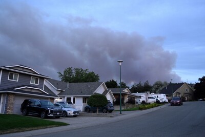
Here at home, she also points to another project that USFA is working on with Esri around evacuations. As she tells Geo Week News, many of these WUI areas have one road in and one road out, which can be a problem for evacuation. If that road is inaccessible during a fire, people don’t know where to go. She’s hoping the WUI Property Awareness Explorer can help spark the next set of tools they could release down the line.
“We wanted to launch this as an awareness tool, and also so we can start getting into people’s vocabulary about embers – ember cast, ember spread – and that it’s not just you. It’s your neighbor putting you at risk, and vice versa, and help people at least have some intelligence around these concepts. The next move is to inform them about evacuation.”
She tells Geo Week News that USFA and FEMA are already working with Esri in creating these next tools around evacuations, helping to find other places where people can temporarily hide out from a fire instead of trying to drive through a potentially inaccessible road. Open areas like golf courses, baseball fields, and parking lots may be uncomfortable, but should be safer to wait out a moving fire.
There is a lot that needs to be done across many different sectors and disciplines to help mitigate risks of wildfires and, hopefully someday, vastly reduce their frequency and intensity. In the meantime, though, people need to be aware of the area in which they live and how that can affect their safety. GIS and spatial data in general can be a major piece of that puzzle, as USFA and FEMA are already demonstrating.
“I always tell people, it’s not rocket science,” said Dr. Moore-Merrell. “This is practical implementation of science, and I think that is very important to understand. It’s taking information and maps, and making them work for the people.”