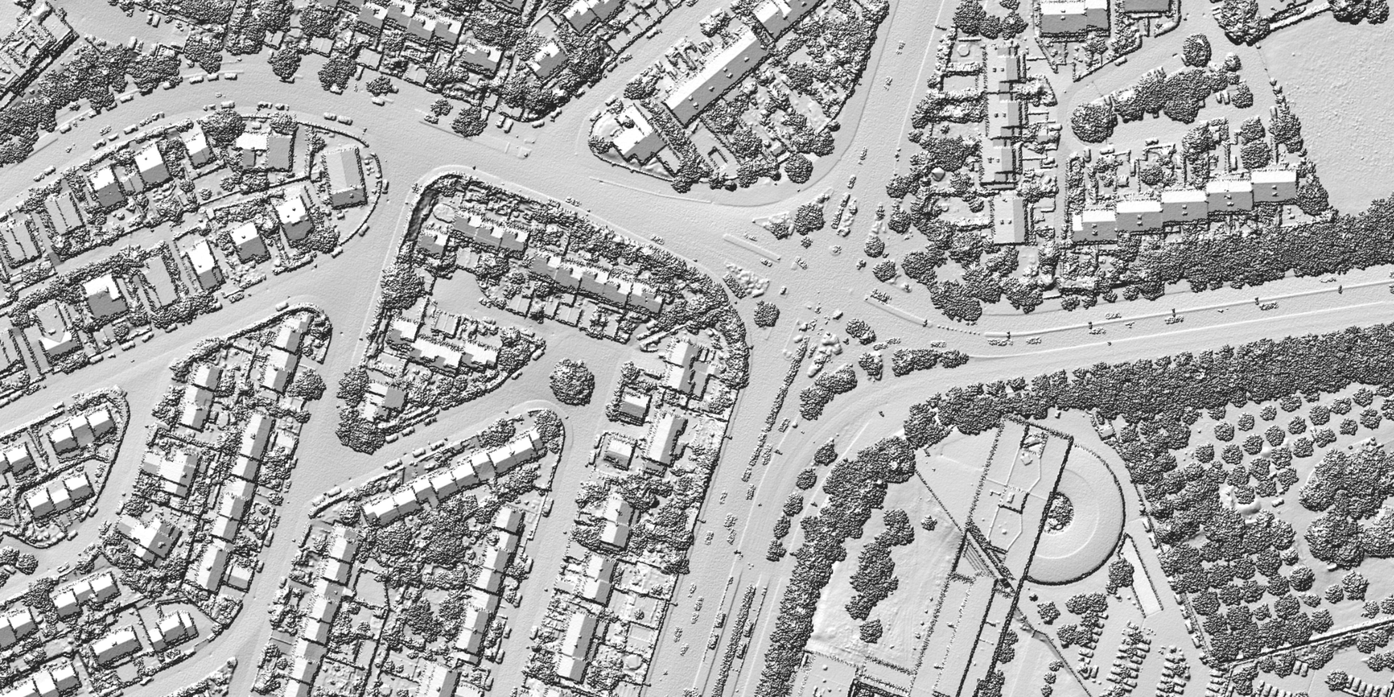
Looking broadly at the aerial mapping sensors recently announced, there is a growing trend around miniaturizing sensors without having to sacrificing their power, and in some cases even increasing their power over previous versions. On the one hand, this leads to larger solutions that are capable of integrating multiple cameras and sensors for crewed aerial aircraft, but can also drive application-specific drone payloads and systems. With more choice for the consumer, it’s now more possible to start with an entry-level system to gain familiarity with new technology, and then scale up to a higher-end system in the future. The diversity and quantity of aerial mapping sensors keep growing, highlighting the continued advancement of this space.
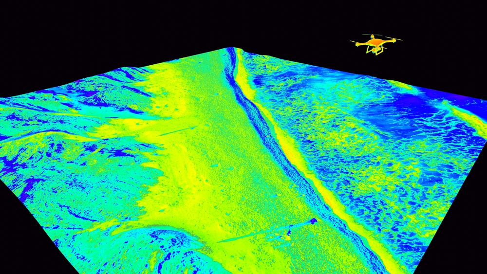
There are different reasons for the growing need for topobathy solutions, something that was covered in a recent article on the Leica CoastalMapper launch. In that conversation, Hexagon’s Vice President of Airborne Bathymetric Lidar Anders Ekelund explained that longer flight can improve the efficiency of current aerial mapping workflows while also opening up new potential use cases, such as river mapping.
The same use case is mentioned in another recent article, this time from RIEGL covering bathymetric drone surveying, published in Hydro International. It covers the principles, applications, and advancements in airborne bathymetric lidar, using the RIEGLVQ-840-G topo bathymetric sensor as an example of what’s possible today.
Drones and crewed aircraft can coexist
The Leica CoastalMapper and Riegl VQ-840-G, as an example, are able to complete projects in the same broad space, but complement each other thanks to the differences in systems for UAVs and crewed aircrafts. Being able to fly with more, and heavier, equipment in a single flight means higher efficiency, as stated in the CoastalMapper piece, but efficiency can mean different things in different scenarios. For example, capturing multiple datasets in a single flight can be more efficient in one application, but another looks at efficiency in terms of simply capturing more data in a single flight in less time, perhaps by flying at a greater height.
There are also possible downsides to such benefits, which may limit overall efficiency gains. For example, when researching market demand for a system such as Fathom, Teledyne Geospatial found that, on the one hand, there was a clear market demand for a system that would capture data from coastline, wetlands, and riverine environments. On the other hand, there was a concern that such a system would require bigger, bulkier sensors, larger aircraft, and a high demand for IT infrastructure.
Then there are common challenges specific to topobathymetric surveying that need to be taken into account when developing any new solution in this field. One such challenge is the changing condition of the water, which translates to the uncertainty of getting viable data during a flight, such as complete maps of the underwater terrain. Other challenges are a lack of skilled personnel and the costs that come with large projects.
The Hydro International article explains why, despite such challenges and limitations, bathymetric lidar is continually evolving. For example, it will play a critical role in modeling sea-level rise in the context of climate change mitigation, as well as disaster mitigation, and sustainable resource management.
While the benefits of crewed aircraft over drones for topobathymetric mapping are higher efficiency and scalability, drones have the added benefit that they are deployed rapidly. Crewed aircraft, on the other hand, can be hard to maneuver in narrow waterways, while drones can fly a pre-defined flight path automatically.
Flight planning software is an enabler of such applications. Today, drone flight planning software uses 3D topographic models so that drones can always maintain a fixed height during a flight. Such added intelligence prevents re-flights and is beneficial for drone lidar surveys in open pit mines and dense forests, according to an article from SPH Engineering with predictions for the drone flight planning industry.
It also notes the importance of AI and automation in guaranteeing data accuracy for photogrammetry and lidar mapping projects, as well as the growing demand for lidar mapping in construction, forestry, and mining drone applications. Autonomous drone operations and BVLOS flights are two enablers for more lidar drone mapping applications.
Lidar is becoming the standard for drone mapping
The SPH Engineering article makes a clear case for further lidar adoption for different industry applications, stating that lidar “offers clear advantages over traditional photogrammetry”.
While many aerial systems today include both technologies, including the CoastMapper, Fathom, and the GeoCue TV1 Lite and TV1. One trend seems to be that more entry-level lidar mapping systems are being released, which over time could lead to an upgrade to a more high-end system.
Aerial mapping sensors today reflect an evolving mapping landscape where innovation is driven by both technological advancement and the demands of specific real-world applications. From the increasing adoption of lidar and AI-powered flight planning software, to the complementary roles of drones and crewed aircraft, signs point to the industry moving toward more specialized, efficient, and scalable solutions.
The variety of platforms and sensors now available empowers users to tailor their tools to specific environments and project needs—whether that means rapid deployment with UAVs or comprehensive, large-scale data collection from crewed flights. The problems that aerial mapping data can help to illuminate continue to grow in scope and complexity, and the continued development of aerial mapping sensors will be key to delivering the insights needed to meet them.