In recent years, Autodesk and Esri have increasingly aligned their technologies through a unique partnership, enhancing the workflows of architecture, engineering, construction, and operations (AECO) professionals. This collaboration has been instrumental in bridging the gap between Autodesk users and geospatial survey users of ArcGIS, particularly in design and construction projects. At Autodesk University last week, the two companies announced the “enhancement” of their strategic alliance through a significant software integration that now allows ArcGIS data to flow seamlessly into Autodesk Forma, streamlining early design and planning processes for AEC projects.
Autodesk Forma Integration
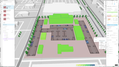
Autodesk Forma is a cloud-based platform specifically designed for AEC professionals, aimed at enhancing the design and planning process. Its focus on integrating various workflows and technologies facilitates collaboration, visualization, and analysis throughout the project lifecycle. Historically, AECO professionals have grappled with the challenges of using multiple tools to integrate contextual data, often resulting in inefficiencies and data loss as they switch between platforms. The newly announced integration of ArcGIS data into Autodesk Forma addresses these issues by providing cohesive, consistent spatial data and analytics right from the outset.
The combined strengths of GIS and BIM technologies during the early design and planning phases empower teams with enhanced mapping capabilities and improved collaboration, which can help reduce project costs and timelines. As Amy Bunszel, Executive Vice President of Architecture, Engineering, and Construction at Autodesk, noted during her address in the General Session, “We all know that context is critical to making good decisions, and geospatial data is an important part of site context.”
In addition to the existing Esri terrain data available in Autodesk Forma, there are plans to incorporate a wide array of contextual geographic data from ArcGIS, including information about buildings, zoning, roads, property boundaries, imagery, and more. This integration enables architects and planners to begin their designs with immediate access to geographic context, leveraging Esri’s ArcGIS basemaps and select data layers from the ArcGIS Living Atlas of the World. Bunszel emphasized, “This means that architects and planners will be able to leverage all this rich data from ArcGIS within Forma, bringing that spatial context earlier in your design process.”
“Together, will enable us to better support our architecture and design communities to design with location in mind,” added Bunszel.
Revit Will Also Benefit
Furthermore, Autodesk Forma connects directly to Docs, Autodesk’s Common Data Environment, facilitating a more integrated relationship between Forma and Revit. Revit users will now benefit from the highly requested feature of accessing site context capabilities directly within their workflows.
“You will be able to easily pull relevant data about a site — such as terrain, existing roads and buildings, and a lot of that other data you can get out of ArcGIS into Revit,” explained Bunszel.
A History of Collaboration

This latest integration builds on earlier collaborations between Esri and Autodesk. Earlier this year, Esri’s ArcGIS basemaps were integrated with Autodesk Civil 3D and Autodesk AutoCAD, providing architects, engineers, planners, and contractors with detailed geospatial data and mapping capabilities. The integration of ArcGIS data into Autodesk Forma is the latest milestone in a strategic alliance aimed at unifying GIS and BIM.
The partnership between these two former competitors has an unlikely origin story, starting with a chance encounter with the President and Co-Founder of Esri, according to Anagnost.
“I met Jack [Dangermond] at a hotel in San Francisco. He was on vacation with his wife, and I said, ‘Why can’t we just work together? I think it’s good for the industry - it would be good for us. You’re good at this; we’re good at that.’”
This candid conversation led to the realization that competition wasn’t a productive battle.
“Over time, we did stop competing. We actually sunset some products… we now rely on Esri products to do some of the things that we were previously using our products for — and that’s a big move. We killed those products and started working on deeper integrations with Esri, and you’re seeing more and more of those coming out,” Anagnost added.
“Esri and their technology is now a critical plugin to the workflows we do with our customers, and its’ going to continue to be that way.”
Industry Impact
While this announcement was one of many rolled out at Autodesk University this year, the impact is likely going to be felt across the industry in a big way, and was very well received by the audience. When Bunszel announced the integration in the general session, she had to temporarily pause her remarks to stop for applause and whoops from the audience.
The enhanced integration of ArcGIS data into Autodesk Forma represents a significant step forward in the collaboration between Esri and Autodesk, bridging the gap between geospatial and design data. By enabling AEC professionals to access critical spatial context from the outset, this integration aims to streamline workflows, improve decision-making, and ultimately lead to more successful project outcomes. The silos between geospatial and AEC data have been built up for quite some time, but an integration like this (and its impacts on design workflows) has the potential to truly bring them down.