In 2017, Leica Geosystems announced the SPL100 single-photon lidar (SPL) sensor. The expertise gained with the SPL100 played a significant role in the development of a new SPL module to be released in 2025, which was announced recently. A hybrid system combining the new SPL module with a large-format camera in a single sensor pod was displayed at the recent Intergeo expo in Stuttgart, Germany.
System specifications and components
The new SPL module will have a 60-degree FoV, compared with a maximum 30-degree fixed FoV of its predecessor, the SPL100. This makes for a larger scanning area on the ground (swath width). Even more impressive is that the new SPL module will have 500 measurement channels, collecting 14 million measurements per second.
When developing the solution, Leica faced two major challenges: enhancing efficiency and a compact design. Both serve to make data collection over large more efficient. The SPL100 weighs 83.8kg and is table high. Details on the size and weight of the new module have not been disclosed yet. Initial reactions to the data capture rates have been very positive.
The hybrid system on display at Intergeo combines the new SPL module and the Leica DMC-4 large-format camera. This makes for a hybrid system where the color information of the camera imagery is overlaid on the point cloud data for a true-color point cloud. The new hybrid system is supported by Leica HxMap, the only imagery and lidar-integrated workflow available today.
Expanding Hexagon’s imagery program
The hybrid solution is meant for mapping projects requiring high-density lidar data and high-resolution imagery. Hexagon offers both forms of spatial data through its HxGN Content Program, as well as elevation and 3D models. Both photogrammetry and laser scanning enable the production of 3D models and maps, and Hexagon captures such data at a national level. For such large-scale projects, a high-productivity solution with SPL makes sense. Leica is currently the only SPL provider on the market.
Hexagon acquired single-photon range measurement technology company Sigma Space in 2016. That technology was originally used to measure the range from the ground to earth-orbiting satellites. It was integrated into Leica’s airborne mapping systems due to the efficiency of the technology, which captures six times more data than general lidar systems at the time.
When that acquisition took place, Leica Geosystems’ John Welter stated that the real reason for acquiring Sigma Space was to expand their imagery program and add an elevation component. The high data capture rates made the program more feasible, as large areas are captured, including the entire US. With Sigma Space’s SPL, Leica acquired a next-generation airborne lidar technology, which was developed into the SPL100 and its successor.
What is single-photon lidar?
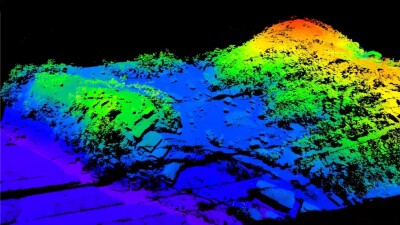
Single-photon lidar is capable of detecting single particles of light. This makes it more efficient than any other lidar. Thanks to that, the laser beam can be divided into dozens or hundreds of sub-pulses. Compared to conventional airborne lidar, SPL captures multiple individual adjacent points. The result is a high point density. The sensor has a very high sensitivity, and the presence of only one photon in the return signal is sufficient to determine the range to the surface of an object. Single-photon lidar operates at lower power levels but requires highly sensitive sensors which may wrongly detect solar photons as return signals. The solution to this problem is advanced noise filtering.
Resource: “Introduction to Pointcloudmetry: Point Clouds from Laser Scanning and Photogrammetry”, Mathias Lemmens (Whittles Publishing).