
Hamilton County, Indiana, has embarked on a revolutionary geospatial project with its 2024 Orthophotography, Lidar, and Basemap Update. This initiative, led by Dewberry Engineering and Ecopia Tech Corporation, an Observer of the European Association of Aerial Surveying Industries (EAASI), aims to transform urban development and environmental management through advanced geospatial data.
This project includes the acquisition and development of four major new geospatial data mapping components:
- 3-Inch Pixel 4-Band Orthoimagery
- 3DEP QL1 Lidar
- AI/ML-driven Planimetric Land Cover Mapping
- 3DHP Elevation-Derived Hydrography Data
High-Resolution Imagery and Lidar for Unparalleled Detail
Central to the project is the acquisition of three-inch pixel four-band Orthoimagery, providing a ground sample distance (GSD) of just three inches. This ultra-high-resolution imagery serves as a cornerstone for urban planning, emergency services, and environmental management, offering unprecedented detail for accurate feature identification, advanced imagery analysis, and property valuation. This imagery will be shared with the Indiana Geographic Information Office (IGIO) to help create and maintain a seamless statewide Orthoimagery data coverage.
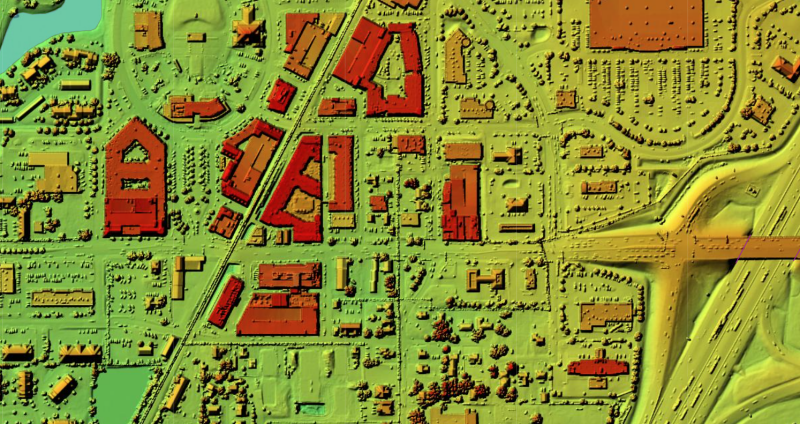
The project also utilizes the USGS 3D Elevation Program's Quality-Level 1 (3DEP QL1) Lidar with an 8 points per meter (ppm) density. This enhanced resolution, a significant upgrade from the county’s existing QL2 standard (2 ppm), is essential for 3D modeling, flood risk analysis, infrastructure planning, and precision agriculture. The Lidar data will also be shared with IGIO and contributed to the USGS 3DEP program to support detailed, accurate statewide and national Lidar data coverage.
In this landmark project, Dewberry Engineering headquartered in Fairfax, Virginia serves as the prime contractor, partnering with Ecopia as the subcontractor for developing the AI/ML Landcover data layers.
AI/ML-Driven Planimetric Land Cover Mapping
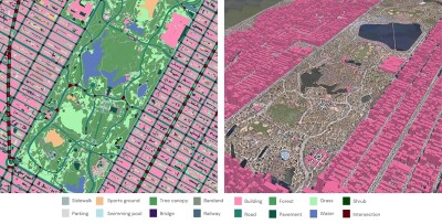
Ecopia Tech Corporation’s AI/ML-driven Planimetric Land Cover Mapping will extract detailed 2D and 3D land cover features from the new Orthoimagery and QL1 Lidar data. This component automates the mapping of fifteen different 2D land cover features like roads, driveways, and parking areas, while the 3D mapping includes buildings, tree canopies, and bridge decks.
These layers will provide invaluable data for emergency and disaster management, infrastructure management, community planning, and environmental conservation. The data will be shared with the Indiana Geographic Information Council (IGIC) and IGIO, serving as a template for future local government and statewide AI/ML-driven Planimetric Land Cover Mapping initiatives.
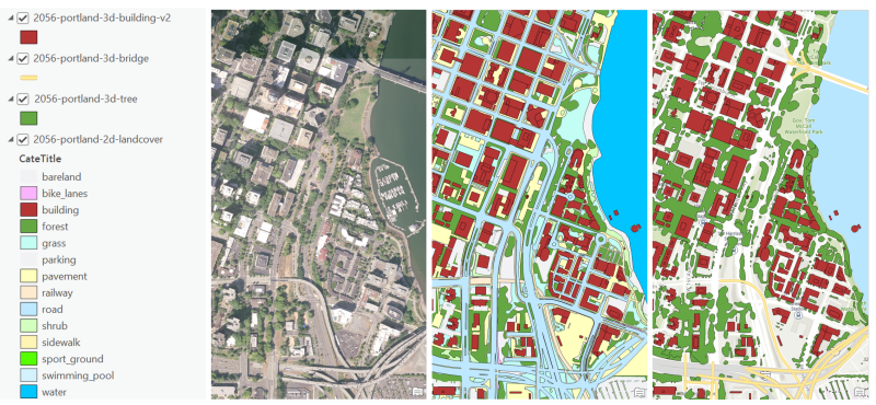
Image 1: Landcover Feature Legend | Image 2: 3-inch Pixel Ortho | Image 3: 2-D Landcover Features | Image 4: 3-D Landcover Features
3DHP Elevation-Derived Hydrography Data
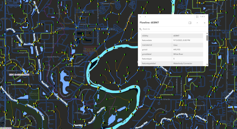
A significant upgrade from traditional 2D hydrography layers, this project introduces a 3D elevation-derived hydrography dataset, leveraging QL1 Lidar data to provide exact horizontal and vertical alignment. This dataset will aid in flood control, pollution tracking, conservation efforts, and more. The data will be shared with IGIO and contributed to the USGS 3DHP program, enhancing statewide and national 3D hydrography data coverage. The Upper White River HUC-8 pilot area will serve as a testbed for future initiatives.
Project Timeline and Next Steps
The project commenced in January 2024 with the development of a detailed production plan by Dewberry and Hamilton County. In February 2024, raw Lidar and Orthoimagery data were acquired during leaf-off conditions. By May and June 2024, Orthoimagery and Lidar data products for designated pilot areas were delivered for independent QA/QC by the county. Upon approval, Ecopia will develop a pilot for the AI/ML-driven Planimetric Land Cover Mapping layers. Dewberry will continue producing county-wide Orthoimagery and Lidar data products, and develop a 3DHP Elevation-Derived Hydrography pilot area. All final data products are scheduled for delivery by December 2024.
Sharing and Collaboration: Beyond Hamilton County
To maximize the project's benefits, Hamilton County offers educational webinars for local officials and partners. Future plans include integrating advanced AI/ML-driven Planimetric Land Cover Mapping with the 2025 Orthoimagery, creating a detailed landcover change detection map layer to highlight year-over-year changes. This commitment to continuous improvement ensures the county's geospatial data remains current and valuable for informed decision-making and sustainable community development.
Hamilton County's project exemplifies how cutting-edge geospatial technologies, coupled with collaboration and knowledge sharing, can revolutionize community planning, development, and resource management for a sustainable future.