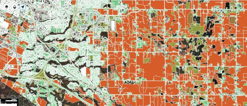
Ecopia AI announced the availability of new agricultural land use vector data, bringing a new level of detail to the 3D Nationwide Land Cover dataset. These planimetric vector data layers will enable government agencies to perform more in-depth geospatial analytics related to water usage, tax assessment, land development, runoff calculations, and other detailed analysis workflows.
The term “planimetric” in the data description above refers to the nature of the provided vector data. It indicates that the agricultural vector data is 2D and focuses on their horizontal positions/geographical boundaries on Earth’s surface, but doesn’t consider elevation or height. This is an important distinction because Ecopia does offer 3D land cover data with height attribution for buildings, trees, and bridges. Ecopia’s data has a >95% geometric accuracy guarantee to ensure features are correctly aligned with their real-world counterparts on Earth’s surface.
The data is ultimately a file of attributed polygon features: the vector data is available in common vector file formats used in GIS applications, including shapefiles. The data format in which the data is delivered depends on the customers’ needs, and is most often conveniently provided to customers through a secure download link, ensuring easy access. There is the option for a different data delivery methods if necessary.
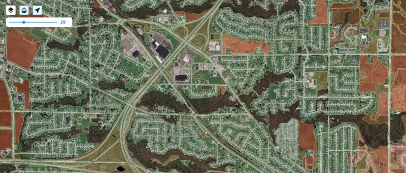
The data is available nation-wide across the US and is an extension of Ecopia’s 3D Nationwide Land Cover which is the most comprehensive, accurate, and up-to-date 3D and 2D land cover vector map of the United States for next-generation analytics and decision-making, providing 14 high-precision 2D data layers classifying different land use types, as well as height-attributed (3D) feature classes for buildings, trees, and bridges. These standard data layers, derived from high-resolution geospatial imagery sourced from Ecopia’s global partner network, currently power a variety of mapping and analytics use cases across the United States, including stormwater management, public safety, natural hazard mitigation, and urban/community planning.
Supporting decision-making throughout the US
With the launch of this additional land use data, organizations will have the choice of further classifying ‘grass’ and ‘agriculture’ features into more specialized layers; Ecopia’s AI-based mapping systems can now classify ‘grass’ as either ‘developed open space’ or ‘wild grass,’ while ‘agriculture’ features can now be differentiated as either ‘pasture’ or ‘cultivated crops.’
The motivation behind refining these classifications was to provide more detailed data to support decision-making across various use cases throughout the US. These classifications deliver further detail about land cover data across the US and possibly give a more comprehensive overview of what’s going on and help support tasks such as agricultural tax assessment, land use planning, water consumption analysis, runoff calculations, and more. For example, understanding the distribution of wild grass can aid in soil erosion prevention and conservation strategies, but the wild grass needs to be distinguished from developed open space, such as maintained grass around a home or other property.
Keepings maps up-to-date with the real world at scale
Traditional methods for producing planimetric land use data with this level of detail require manual digitization and classification of geospatial imagery. Traditionally it has been time-consuming and expensive for agencies to create high-precision data through manual digitization. The time-consuming nature of manual digitization can mean that by the time the data has been created and is ready to use, it’s already stale and out-of-date. Ecopia’s AI-powered mapping systems streamline this process, quickly creating comprehensive, accurate, and up-to-date geospatial data while maintaining the accuracy of a GIS professional.
Offering a nationwide dataset provides comprehensive coverage and scalability, enhancing decision-making across states and agencies with reliable and uniform geospatial information. Ecopia’s customers pay for this data to save time and money from manually digitizing features, as well as to efficiently keep maps up-to-date with the real world at scale, which is near impossible to do manually given how quickly the world changes. Ecopia’s data is also standardized across geographies so the veracity of the information is not compromised by the different interpretations or manual digitization techniques of individuals.
The four new planimetric layers produced by Ecopia further align the company’s data offerings to similar environmental datasets produced by the US government, including the USGS’s National Land Cover Database and NOAA’s Coastal Change Analysis Program (C-CAP) data. Earlier this year, Ecopia’s AI-powered mapping systems increased the resolution of C-CAP data by 900x (from 30 meters to 1 meter), providing open access to high-resolution land cover across 1.5M square miles of US coastal communities. This technical alignment with other authoritative datasets commonly used for geospatial analytics also complements recent investments in the USDA’s National Agriculture Imagery Program (NAIP), providing deeper insights for government agencies to leverage in various environmental stewardship initiatives.