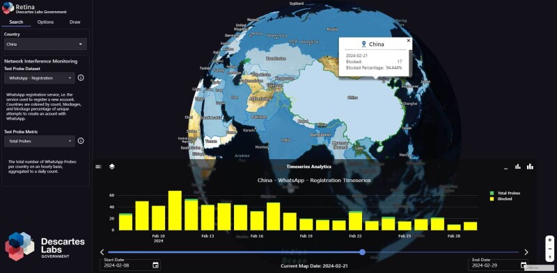
Descartes Labs Government (DLG) is announcing the launch of Retina (Rapid Exploitation Through Interactive Analysis) at GEOINT 2024. Retina is an innovative solution that integrates Open Source Intelligence (OSINT) and Geospatial Intelligence (GEOINT) for rapid intelligence extraction, enabling government agencies to see the world in real-time clarity through a single, streamlined interface.
Descartes Labs Government will showcase Retina at booth #2003 during GEOINT 2024, along with other product demonstrations (see in-booth product demo schedule below). Attendees will witness how Retina simplifies complex data sources, efficiently manages information, aggregates verified sources, and delivers near-real time event reporting. This solution empowers intelligence communities to address the world’s most pressing challenges by uncovering complex patterns to identify and monitor geopolitical, economic, and environmental threats.
Complementing the release of Retina, Mr. Davis will lend his expertise to the 'GEOINT Fusion for Decision Advantage' panel on May 6th at 3 pm in Vista Hub, exhibit hall 1033. He will join presenters from major organizations in the global geospatial technology sector, including BlackSky, Unseenlabs, Microsoft Azure, and Ursa Space Systems for this panel. At a global scale, government decision-makers have utilized many types of satellite imagery from various sensors, including SAR and RF. However, each is often used for a specific purpose. This panel brings together experts from government and industry to discuss the potential for fusing these data types, leveraging the strength of each to better support decision-making.
Visit the DLG team at GEOINT 2024, booth #2003 for the unveiling of Retina and experience the power of revolutionary geospatial science through data-agnostic, deep-tech solutions.
Descartes Labs Government In-Booth Product Demonstration Schedule:
Descartes Labs Tech Stack & Tool Modernization
Monday, May 6, 10:30-11:00 am
Tuesday, May 7, 1:00-1:30 pm
Wednesday, May 8, 11:00-11:30 am
William Evonosky, DLG’s Lead Applied Scientist, will conduct a demonstration highlighting a recently integrated Large Language Model (LLM) solution on the DLG Explorer interface which allows for natural language search and visualization of imagery from the Descartes data catalog. Additionally, he will demonstrate a no-code “node-editor” interface that allows for the creation of front-end dashboards and data processing pipelines via a drag-and-drop interface. Lastly, the demonstration will include a dashboard that provides critical infrastructure monitoring for anomalous movement in near-real-time using InSAR.
Workflow Improvements with Effective Data Management
Monday, May 6, 2:00-2:30 pm
Tuesday, May 7, 11:00-11:30 am
Wednesday, May 8, 10:30-11:00 am
Dr. Daniela Moody, VP of Technology, Insurance at DLG and previously CTO at Geosite (recently acquired by DLG), will demonstrate the Mission Management Tool (MMT). It was designed and developed to support Search and Rescue (SAR) operations for the Air Force Rescue Coordination Center (AFRCC). MMT helps to shorten the time between when a potential crisis is detected to when resources are deployed to help those in need, in a manner that streamlines existing workflows of AFRCC and Alaska RCC in a secure, cloud-based solution.
OSINT & GEOINT Data Fusion to Accentuate Complex Signals for Decision Making
Monday, May 6, 11:30-12:00 Noon
Tuesday, May 7, 2:00-2:30 pm
Wednesday, May 8, 11:30-12 Noon
Alex Courtright, DLG Technical Program Manager, will demonstrate Retina. DLG collaborated with the Army Intelligence and Security Command to build a mission-driven dashboard that collates global OSINT data to help operators establish situational awareness of real time events. Utilizing our expertise in geospatial data management, visualization, and analytics, this mission driven dashboard enables timely identification of complex signals from disparate data sources.
Source: Descartes Labs


