A typical mapping backpack? Cameras, laser scanners, computing system, all worn on the back
Source: UC Berkeley @QuestScience
When considering the mapping backpacks marketed to the surveying industry by well-known firms such as Leica and Microsoft’s Ultracam Group for this article, I knew I had to ask where we really are in our understanding of the technology. What is a mapping backpack? What developments led to their invention? Why would we want them? What are their potential applications?
What a Mapping Backpack Is
For purposes of this discussion, here is my definition of what a mapping backpack might be comprised of:
- Imaging sensors that dynamically capture a person’s surroundings
- A computing unit for storing data collected from these sensors
- All of the above should be integrated into a singular unit that is lightweight enough to be strapped to a person’s back, allowing them to simply walk around the site that they would like to map or document with images
- A workflow that enables the user to work out where the data has been captured and produce a continuous or immersive visualization of the environment that they have captured.
- The system should perhaps enable the data collected to be ‘good’ without the person wearing the backpack needing to do much more than walk in a straight line
The Technologies That Made Them Possible
It is perhaps fair to say that Applanix changed the way that we map in the late 1990’s when they launched their first inertial navigation system (INS) for aerial mapping purposes.
It was the first high-accuracy INS systems small enough to enable reliable direct georeferencing of aerial photography. This increased the viability of airborne topographic mapping, and the digital workflows that were shortly to come online. Since then, these technologies have continued to evolve, becoming smaller, lighter, and cheaper. They’ve brought about land-based mobile mapping, then trolley-based indoor mapping systems, unmanned aerial vehicles… and now we have backpacks.
Why We Want Them
Both at professional and consumer levels, we have seen an increased awareness of immersive imaging, its value, and the technologies that enable it.
Customers in general are demanding information that portrays the environment in more realistic ways. Huge amounts of footage are being collected from among the pack of high-profile cycling races to show what route or race looks like from the rider’s point-of-view, and without a second thought we check out what a new coffee shop looks like on Streetview.
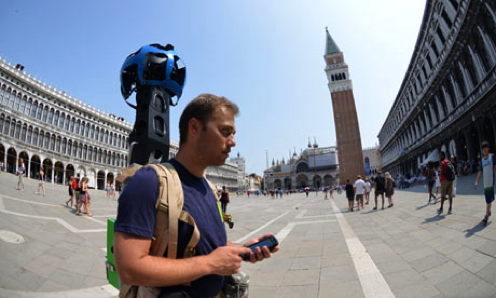
Google Trekker collecting Streetview imagery in Venice, Italy, Source: The Guardian
Within professional contexts, GIS techies working in disaster management would love to know what a site looks like. Asset managers are seeing the value of data holdings that provide a view of the form and condition of their facilities without requiring them to leave the office. In other words, mobile backpacks were developed to meet the need for collecting imaging data from first person view, and fast.
In addition, there is also the case of the surveyors who want to reduce the time taken to laser scan the inside of a building from one day to just an hour or so. The mapping backpack promises to help meet this need by offering increased mobility and efficiency. It promises that businesses will be able to complete more work in a day, and potentially be more profitable. Of course, if health and safety considerations permit a data collection to be completed in a mobile manner by a survey team of one person, then this only goes to increase the per-capita productivity of a project.
Practical Considerations
There are potentially a wide variety of uses of imaging or mapping data that provides an immersive view, and which has been collected in as efficient a manner as possible. Generally speaking, perhaps such a breadth of uses mean that everyone surely wants a mapping backpack?! If this is the case, will any type of mapping backpack be suitable?
In the next post we will look closer at the types of data that we might really want to collect and the types of mapping backpacks that we are now seeing being offered.


