Contributed by Elina Punkkinen, Business Development Manager at Leica Geosystems
Yacht racing is a unique sport where vessels of different sizes and designs can compete against each other in the same race. Some designs are inherently faster than others, so achieving fairness means applying varying handicaps to individual yachts to adjust raw race times. This ensures the best sailors win, not just the fastest boats.
Calculating these handicaps in such a diverse event requires meticulous measurement of each vessel, including hull shape, weight, and sail area.
However, measuring these yachts still relies on manual tools and time-intensive techniques. These often struggle to precisely capture a yacht’s true dimensions or account for its natural balance.
To overcome these challenges, the Offshore Racing Congress (ORC), which oversees the measurement of yachts to ensure fairness, turned to 3D laser scanners to create fair handicap ratings. Precision measurement is redefining fairness in yacht racing.
The Progression in Measurement
Precision is essential in measuring racing yachts to ensure fair and balanced competition, as even minor inaccuracies in handicap assessments can affect outcomes. Over time, yacht measurement techniques have evolved. Traditional approaches use total stations or hand measurements to capture hull shapes.
To further enhance efficiency and accuracy, the ORC embraced laser scanning technology. "This cutting-edge approach allows us to capture all necessary features of a yacht in a fraction of the time while maintaining high-quality data," says Alberto Pindozzi, ORC technical officer and superyacht manager.
By leveraging these advancements, the ORC continues to uphold its commitment to innovation and fairness in yacht racing.

Scanning a World-Class Racing Yacht
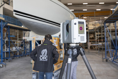
In the summer of 2024, the ORC deployed advanced 3D laser scanning tools at a shipyard in Pietarsaari, Finland, home to world-renowned yacht builder, Nautor Swan.
The process began with identifying and marking four target points – key vertical distances between the main deck and the waterline. These markers were pivotal for calculating metrics such as displacement, wetted surface area, and hydrostatic data. Once marked, the laser scanner was used to capture the yacht’s complete geometry in 17 setups, achieving a resolution of 3mm at 10m range.
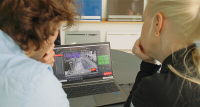
The team utilized a user-friendly laser scanning mobile application to oversee the outputs in the field, ensuring that all essential details were captured. This on-site visualization enabled immediate alignment and registration of scans, prioritizing speed and reducing the likelihood of having to revisit the site. “With total stations, we’ve needed at least six hours in the field to properly acquire a boat’s shape,” says Pindozzi. “With laser scanning technology, we precisely captured the ClubSwan43 in half the time.”
Another advantage of laser scanning was its ability to adapt seamlessly to the yacht's resting position on its cradle. This flexibility allowed the team to account for any tilt or inclination during scanning, further enhancing the accuracy of the measurements.
"That speed and flexibility greatly enhances the measurement process,” notes Pindozzi.
Turning Scans into Race-Ready Data
Following the scanning phase, the team moved to the post-processing stage. Here, they imported the point cloud data into specialized software to clean, align, and refine the dataset. Noise removal and isolation of specific surfaces enabled the creation of a highly detailed 3D digital model of the vessel, capturing all of its critical features required for rating certificates, including the hull, sails, rigging, and propeller.
Key data points, including the X, Y, and Z coordinates of the targets and the complete 3D model, were then exported into the ORC’s proprietary software. This allowed the calculation of essential performance metrics, such as displacement and hydrodynamic forces, including lift and drag. These measurements were subsequently stored in the ORC’s offset database, simplifying the certification process for future ClubSwan43 owners.

“Knowing the hull shape and geometry is one of the most important factors for predicting a boat’s performance,” explains Pindozzi. “So, it’s essential to accurately measure those elements to ensure each boat is rated properly for racing.”
By incorporating this comprehensive 3D model and analysis, the ORC can provide rating certificates that account for performance differences across varying wind conditions and course geometries. This approach is especially crucial in regattas, where yachts of all sizes and designs compete, to ensure a fair and competitive playing field.
A New Standard for Fair and Fast Practice
The success of this project signals a new era for precision measurement across diverse fields. By leveraging laser scanning technology, the ORC has not only set a new benchmark for fairness in yacht racing but has also highlighted a broader technological shift – one where advanced technology becomes the cornerstone of fast, fair, and accurate measurement across a number of unique applications.
This technological leap extends far beyond sports. In law enforcement, similar laser scanning techniques are revolutionizing forensic investigations. For instance, Brazilian Federal Police are now using advanced 3D laser scanners to quickly and accurately document crime scenes, capturing critical evidence with unprecedented precision.
By enabling precise measurements across different fields, laser scanning technology is proving valuable in scenarios that require detailed documentation. From carefully measuring yacht hull shapes to meticulously recording crime scene evidence, these tools offer a more accurate and efficient way of capturing complex spatial information.
As laser scanning technologies become more accessible, we're witnessing a transformation across industries – from maritime sports to law enforcement – where precision, speed, and accuracy are paramount.
 Elina Punkkinen is Business Development Manager for Building Solutions & Reality Capture division at Leica Geosystems. Based in Finland, she has worked in the construction technology and geospatial sector for over 15 years, specialising in laser scanning, BIM software, and digital construction. She holds a Master of Engineering in Industrial Management from Metropolia University of Applied Sciences in Helsinki.


