This is the second in a two-part series on current trends in mobile LiDAR. Click here for part one.
Now that we as an industry have realized the efficiency gains that can be had by capturing data on the move, a couple of trends are becoming apparent:
New systems are often used in new contexts
We continue to look for new application contexts in which to implement our shiny, new, and flexible mobile mapping systems. As some manufacturers have begun to hint at, perhaps the noise-levels of current generation LiDAR sensors are beginning to permit the interpretation of distress in road surfaces in addition to surrounding road-side assets?
Personally, while I applaud mobile data collection being applied in a wider range of markets, we need to be careful to ensure we validate that results are fit-for-purpose if we choose to push the boundaries of what sensors and systems have been used for previously.
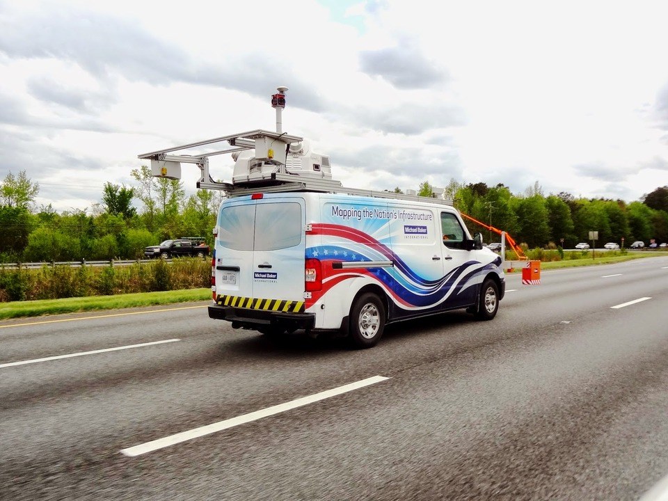
This leads to why it was encouraging to see in May that Michael Baker International had successfully built their multifunctional measurement vehicle comprising mobile LiDAR sensors cameras for interpretation of surrounding assets, pavement imaging sensors (from Pavemetrics) for collecting data to help assess pavement condition (e.g. ruts, roughness, cracks in the road surface), together with forward-mounted ground-penetrating radar (GPR) sensors (from GSSI) to provide further information related to structures immediately below the road surface.
Baker are not the first to implement systems similar to this; Mandli Communications have been delivering systems that couple both LiDAR and pavement imaging systems on the same vehicle for some time now.

Michael Baker International’s mobile system for “Mapping the Nation’s Infrastructure” (www.mobilelidar.com)
The reason why I am a fan of the Baker system is that they have chosen to use the correct tools (sensors) for the job that they were designed. On a personal note, it’s pleasing to see a system such as this because it merges characteristics of the Lynx and the pavement data collection systems that I used to sell.
Imminent requirements: data management and workflow
With the increased understanding of how mobile mapping/data collection systems function and behave, together with an awareness of the capabilities of a wide range of sensor types; the development of systems that ‘do more’ will become commonplace.
In my opinion, this is brilliant – so long as we keep an appreciation of how the data from a particular sensor or system matches with the business requirements of the application that it is collecting data for. While we are seeing an increased number of hardware configurations to support multiple sensors, together with evolution of the sensors themselves (smaller, lighter, optimized), it is not in the hardware where we should see the next stage innovation.
Instead we still have a way to go in the way that we handle increased data volumes efficiently. Examples of vendors that have made excellent strides in optimizing this process do indeed include the likes of Fugro and Mandli. However, with such a variety of systems now being used, there is still room for improvement in the software workflows used to collect, process and analyze data coming from multiple sources. We also need to ensure that we are aware of how we analyze the data that we collect; is it really telling us about the phenomena that our client who has invested in our services is wishing to understand?
So yes, we are beginning to approach the stage where we are capturing every dimension. Going forward, while the new sensors and systems look impressive, it will be pleasing to see the pace of innovation in the unseen management of collected data that will increase the maturity of this market further.


