by Keith Cooke, Esri
At the end of a lonely cul-de-sac in San Jose, California, a streetlight shines its beam on nothing much. A fence separates the sidewalk from sanctuary habitat for the western burrowing owl. Because of the placement of the light pole, the angle of the mast arm, and the distribution of the light, most of the it falls on the owl’s side of the fence. This is optimal for nobody, least of all the owls, whose circadian rhythms are disrupted by the unnecessary nightlight.
It’s an egregious example of something found in cities all over the world. Streetlights are installed with too little forethought beyond simple calculations rather than a serious design-oriented analysis.
When we want to publicize a problem, we “shine a light on it.” When we want to make something clear or understandable, we “illuminate” it. These metaphors assume more light is always the answer. But it isn’t—not always, and not when light itself is the problem.
Look around your municipality. You’re likely to see lights with illumination not directed where it’s needed most. You may see lights whose placement near hills distributes the light so most of its beam-spread is wasted. Or you may notice places where light should fall, but doesn’t: bicycle lanes, crosswalks, and other spots where darkness can cause fatal crashes. Modern LED streetlights can be designed so that light falls where it should. Still, too often it doesn’t.
Take in all the places where light is not deployed tactically, and all the small errors compound. It’s expensive – unnecessarily so – on many fronts. It’s a major blow against the concept of smart cities and urban sustainability, each wasted photon representing a dollar figure. And it casts pockets of the city into unnecessary darkness at odds with government’s duty to provide for public safety.
For too long, cities have approached light almost as an afterthought, employing a one-size-fits-all approach to lighting design. This is the antithesis of the “smart city” ideal. Smart electrical grids allocate power in the most efficient manner possible—why not apply the same thinking to lighting networks?
A Geographic Approach
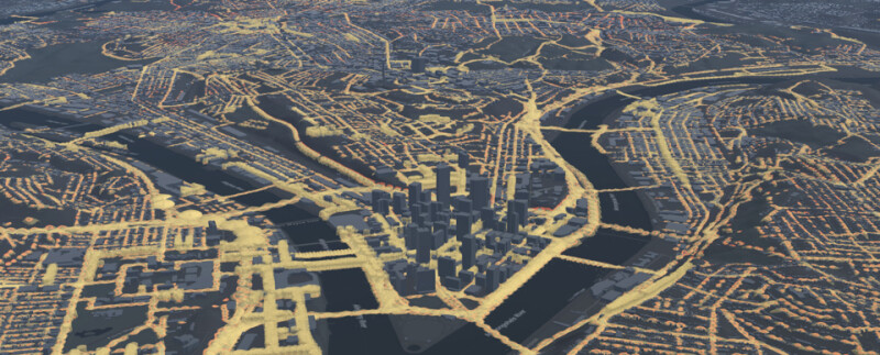
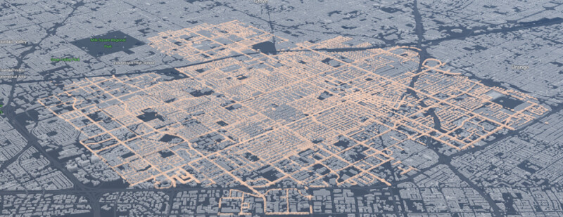
Any city is a complex system of systems. A 3D digital twin of infrastructure—traffic, utilities, public transit, pedestrians and cyclists, parks, construction—helps simplify the complexity. Built and maintained with geographic information system (GIS) technology, these geospatial digital twins provide a complete view of the city as it is. With the ability to model scenarios and process large amounts of data, they also show the city as it could be.
Key to the utility of these digital twins is the way they depict the true 3D topography of a city. Inclines, hills, ravines, dips in the road: none of those show up on a normal 2D map. A digital twin of a city’s lighting system can convey this information accurately and reveal how light falls on each location.
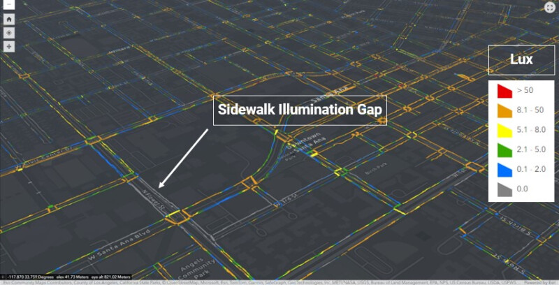
It is now possible to apply photometric models of hundreds—or even thousands—of streetlights throughout a city, projecting this data onto a GIS map. The projection reveals how the lights do their work throughout the urban landscape, including accurate visualizations of the beams.
The public safety implications alone are significant. The U.S. Department of Transportation estimates that adding additional lighting to intersections can reduce pedestrian injuries by over 40 percent. And that just considers the quantity of light, not its strategic deployment. A geospatial digital twin can show exactly how much light is falling on a bicycle lane, for example. A digital twin’s ground-level view can show exactly what a driver, pedestrian, or bicyclist will see when approaching or crossing an intersection.
The consequences of lighting choices affect nearly every aspect of a city. There is, of course, the cost savings and efficiency gains that accrue from more strategic lighting. (That light on the owls is a drain on both resources and budgets.) This is difficult to calculate—streetlights are not typically metered—but better lighting can affect a city’s economy in other ways. A city might want to brighten certain corridors with high economic activity, for example. A geospatial digital twin makes these connections.
Enlightening Equity
Transportation departments across the nation have begun to address issues of equity and lighting is an important facet of these considerations. Again, a geospatial twin of a lighting system can help.
Sometimes the problem is a dearth of lighting. In Seattle, city officials discovered that a certain neighborhood—one with many refugees, people of color, and low-income residents—was much more darkly lit than the rest of the city. The problem was that Seattle relied on self-reporting to fix broken streetlights. People in these neighborhoods were often wary of interacting with the government. Instead of relying on residents to do the reporting, a digital twin could identify and flag outages, hastening repairs.
In other situations, the problem is too much lighting. Law enforcement often equate an increase in light with a decrease in crime—a connection for which there is real empirical evidence. As a result, some neighborhoods are overly lighted. This contributes to light pollution in a city, which studies have shown has real adverse health effects disproportionately felt in lower-income neighborhoods. A geospatial digital twin can help identify areas where crime rates are higher and lighting insufficient to ensure those streets get as much light as they need, but no more.
Finally, there is the quality of light—an issue that combines both problems. Lighting decisions affect how well a streetlight reflects different skin tones ensuring pedestrians who are people of color are safeguarded equitably.
Any streetlight solution must therefore consider all three problems. A geospatial digital twin provides a way to integrate many datasets as layers on the map. In this way, different city agencies can examine how lighting affects crime, public safety, economic development, operational costs, and the overall quality of life.
Light and the Urban Tapestry
Like any other facet of critical infrastructure, light is an essential part of the urban tapestry. That we take it for granted is a testament to its ubiquity. Improving lighting systems begins with understanding how they interact with any city and its unique geography.
The cul-de-sac streetlight shining on an owl habitat reminds us how unique cities can be. Our lighting decisions even effect the natural world at a time when cities are getting more serious about preserving urban ecosystems. Accurately placed lighting, guided by a geospatial digital twin, shines where it is most wanted and needed. And it leaves the owls in peace.
Learn more about the possibilities of a geospatial digital twin.

Keith Cooke is the Director of Planning & Community Development Markets at Esri. A graduate of Auburn University, he has been a GIS professional since 1994 and has worked for planning and community development agencies at the regional and municipal levels. He is a frequent speaker at GIS, community planning, and economic development events and is an active member of the American Planning Association, where he has conducted nearly 100 hands-on GIS workshops for planners since 2004 at the National Planning Conference and state chapter conferences.