The idea of a “smart city” is one that is met with – charitably – mixed emotions from the general public. On the one hand, everyone wants their life to be more convenient, and the technologies offered by the most advanced cities around the world undoubtedly make everyday activities more convenient and seamless in day-to-day life. On the other hand, people often have a negative interaction with this kind of technology as they see it as unnecessarily invasive, no matter what it’s actually doing. Granted, that’s not to say they’re not always wrong, as checks for these tools are always necessary to ensure that cities are, in fact, acting within the law.
That being said, even if we don’t think of technologies as “smart city” technology, there’s no denying that modern urban planning almost by definition needs to be on the cutting edge of technology. Cities are becoming increasingly populated, with citizens who expect convenient movement all while ensuring the city is not contributing to the growing crisis around the planet’s climate. There are lots of different technologies involved in these efforts, but as one would imagine geospatial and reality capture technologies are heavily involved in these efforts, something that we’ve covered extensively at Geo Week News. With that in mind, below you can find six examples of our coverage around how geospatial technologies – including lidar scanners, GIS, and more – is being used by governments in urban planning and smart city development.

Building the foundation for smart city development is complex, but the pay off is worth it
Before getting into some specific case studies, it makes sense to look into what exactly the development of a “smart city” looks like. Often, when we see coverage of smart cities and municipalities that best take advantage of new technology, we are presented with the end result. There’s certainly value in seeing that end result, too, as cities who haven’t made these investments need models to which they can aspire, but that’s not the whole story. For this article, Geo Week News spoke with experts from both the public and private sectors to discuss what those early stages of “smart city” technology implementation looks like, delving into both the positives and road blocks that come up in this work.
Digital twins in the fight to mitigate urban heat islands
In terms of putting this into practice, we start not with a project from a city government itself but rather a study involving urban planning in New York City. One of the largest cities in the world. New York has had to develop over the vast majority of its land to accommodate its massive population, which is necessary but also leads to other problems. Specifically, overly developed land ensures that those who live in these areas will have to deal with greater degrees of heat thanks to what are known as “urban heat islands.” This article highlights a project from a team at Cornell University working to counteract these effects utilizing geospatial technology. Specifically, the team is mapping all of the trees in the city and determining the areas where more green is necessarily for the local citizens to more comfortably go about their day-to-day lives.

Exploring Barcelona's Urban Innovations: Superblocks, Sustainable Mobility, and Future GIS Possibilities
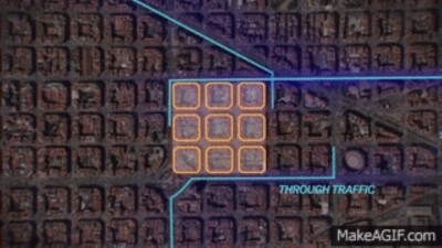
For this article we have another example of technology being used in real urban planning workflows, but this time we head across the Atlantic to the city of Barcelona. One of the largest cities in Spain, Barcelona knew they needed to develop with sustainability in mind, leading to a variety of strategies to maximize the value it can provide to their citizens. In this article, guest author Henrique Reis highlights some of the ways GIS and other tools are used to innovate work throughout the city.
Inside One of Europe's Largest Urban Development Projects
For this particular case study around urban planning, we stay in Europe but move a bit further east to the city of Vienna, the capital of Austria. This is one of the fastest growing cities in Europe and consistently ranked among the most livable, and they are looking to continue striking that balance as their population grows. In this article, Esri’s Brook Patrick looks at how city employees utilize GIS and other tools to revitalize a former brownfield area to make it a space the city can be proud of and that accommodates the growth Vienna is experiencing.

In Washington, DC, Planners Envision More Housing in Historic Districts
The previous article about Vienna is far from an outlier. As the global population continues to gravitate toward cities, over half of the world’s population is expected to live outside the United States, and back in the US cities are grappling with the same realities. The nation’s capital, Washington, D.C., is in the midst of these changes as well as they look to develop historic districts, trying to keep the same feel that had already existed while also providing key tools to maxmizing the value provided by the city.
How are maps and data defining the future of the mobility and traffic technology sector?
Recently, Geo Week’s Editorial Director, Jeremiah Karpowicz, traveled to the Intertraffic conference in Amsterdam. Technology monitoring traffic and transportation more broadly is perhaps the most important piece of “smart city” technology as, at least in the United States, driving is the main mode of transportation and how all systems interact is crucial to ensuring efficiency and safety throughout the municipality. With that in mind, Karpowicz reported from the Intertraffic show, exploring some of the innovations on scene at the event.


