What connects a Czech urban planning institute, a team of super-secret American spies, a father-daughter duo fighting for fair redistricting in California, African NGOs conserving wildlife, and a former child of the Kosovo Civil War who now leads global efforts to clear landmines? Add to that a team confronting the rising threat of sea levels in the Pacific, the Berkeley Police Department’s focus on accountable policing, and a mission-driven doctor fighting a deadly epidemic? Or even how businesses like McDonald’s, Nike, and FedEx are transforming how they operate?
At first glance, these stories seem worlds apart. Yet, they are intricately linked through the efforts of individuals and organizations working to solve some of the most pressing global challenges, often in unexpected ways.
David Yarnold’s The Geography of Hope powerfully illustrates how Geographic Information Systems (GIS) can drive meaningful change through the smart use of technology. A Pulitzer Prize-winning journalist and former President of the National Audubon Society, Yarnold leverages his storytelling expertise to emphasize the individuals behind the technology, showcasing how communities can harness GIS to tackle complex challenges and transform their world.
A Journey Through Global Transformation
From the very beginning, Yarnold invites us to see GIS not just as a tool but as a means of connection – between people, places, and ideas. The title, The Geography of Hope, sets the tone for a book that is both optimistic and grounded. It tells readers that geography – our understanding of space and place – can be a force for good when combined with hope, vision, and action.
The book opens with a personal reflection on Yarnold’s introduction to the world of GIS. His first encounter was at Esri’s annual User Conference in San Diego in 2011, where 15,000 self-proclaimed “map geeks” gathered to share how they were using GIS to address the world’s most pressing problems. This moment was a revelation for Yarnold, marking the beginning of a new chapter in his professional journey.
“I went into this book knowing I was writing about what a friend and many in the GIS industry call ‘the most important technology that people have never heard of’,” Yarnold notes right in the beginning.
The book is structured around a series of case studies, each representing a unique way in which GIS is being used to address pressing challenges. Yarnold moves seamlessly between cities, countries, and even continents, painting a vivid picture of how geospatial technologies are being deployed to solve everything from urban planning dilemmas to environmental conservation efforts. In each chapter, the technology fades into the background, while the people who wield it take center stage.
Democratizing Democracy: The Story of Prague
One of the most compelling stories in the book is that of Jiří Čtyroký and his team at Prague’s Institute of Planning and Development (IPR). In the chapter “The Life Water of Prague,” Yarnold introduces us to a group of GIS experts tasked with balancing the preservation of the city's historic architecture with the need for modern infrastructure. Led by Čtyroký, the director, the team consists of 42 GIS specialists and around 200 architects, lawyers, and administrators – many under 40 – using data to enhance the city's livability. Their work spans from analyzing traffic patterns to monitoring climate resilience efforts.
“Prague, with its complex political system, was doing groundbreaking work in citizen engagement, and it turned the GIS experts into unlikely heroes. And they were facing threats from bureaucrats and corrupt politicians, which gave the story a dramatic twist,” Yarnold told me in a recent interview.
What’s fascinating about this story is not just the technical expertise on display, but the energy and optimism of the team. Yarnold captures the youthful enthusiasm of these urban planners, whose work gives them a sense of purpose in shaping their city’s future. A standout moment occurs when the institute successfully uses GIS to challenge the Czech president’s decision to restrict public entry to Prague Castle, ultimately restoring access to this important cultural site.
Democracy in Action: The Census and Bakersfield’s Redistricting
Yarnold next takes us to Bakersfield, a small city in southern California. In the chapter titled “Fair Lines Make Fair Lives”, we meet Jesus Garcia and his daughter Sophia, who are fighting against gerrymandering in this deeply conservative city where a white minority had dominated the political landscape for years.
Gerrymandering – the manipulation of electoral boundaries to favor one political party over another – has long been a tool of disenfranchisement in U.S. politics. This story is about the Garcias, who worked with U.S. Census official Deirdre Bishop to create a “Unity Map” that reshaped Bakersfield’s political districts. In a region where Latino and Sikh communities were historically underrepresented, technology became the tool to level the playing field. The result? A more diverse city council and the election of Manpreet Kaur, a young Sikh woman, symbolizing the shift in power dynamics.
Yarnold walks us through their struggle as they navigate the complexities of local politics and face resistance from those in power. In the end, the map is approved, marking a significant victory for democracy.
“For a city in one of the reddest parts of California, this was a groundbreaking moment,” he says in the interview.
Spies to Humanitarian Aid: GIS in National Security
If the first two chapters weren't interesting enough, the third chapter reads straight out of a Hollywood thriller script. In “Mapping an ‘Unfair Advantage’”, Yarnold opens with references to Osama bin Laden and September 11, diving straight into the world of spies and national security.
He introduces Letitia “Tish” Long, the first woman to lead a U.S. intelligence agency, who had been in her role as director of the National Geospatial-Intelligence Agency (NGA) for just a week when she received urgent news. Two analysts rushed in to present aerial images, declaring, “We think we may have found Osama bin Laden”!
While the film Zero Dark Thirty gave us a glimpse into the world of GEOINT while dramatizing the hunt for Osama bin Laden, Yarnold reveals the reality was more complex. Through interviews with GEOINT experts and former NGA veterans, including Robert Cardillo and Keith Masback, Yarnold digs deeper into the real-life role of GIS in high-stakes military operations and disaster response.
Explosive Hazards to Hope: Reclaiming Minefields for Communities
The chapter "From Deadly Debris to Renewal and Rebirth" explores the transformation of minefields into livable spaces. From Mozambique to Sudan, Afghanistan, and Ukraine, over half of the world’s population resides in areas plagued by unexploded landmines and other munitions. In Zimbabwe, elephants tread on landmines buried nearly five decades ago.
Here, we meet Valon Kumnova, who leads operations at the Geneva International Center for Humanitarian Demining. Growing up during the civil war in Kosovo, Kumnova has since committed to ridding the world of the deadly debris of war.
As the chapter explores how GIS is utilized in managing explosives, a surprising element emerges – it also becomes a narrative about gender equality. “I hadn’t anticipated discovering that women were leading many of these GIS-based efforts in the explosives industry – an area traditionally dominated by men. And how their involvement can enhance progress and safety in mining and construction projects,” reflects Yarnold.
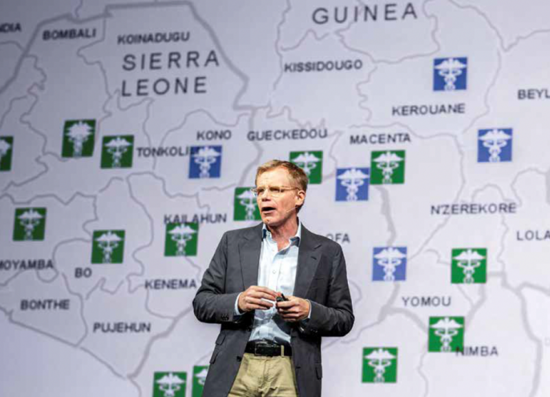
Tracking Ebola: The Power of Maps in Crisis Management
The chapter "Arresting Ebola" reads like a gripping detective novel, introducing Bruce Aylward and his battle against the outbreak, as we navigate the complexities of local customs and mistrust that obscure the virus's path. With witnesses disappearing, Aylward uses maps as vital tools to follow clues, marking the beginning of his six-month commitment as the World Health Organization's (WHO) special representative at the command center in Guinea.
As Aylward leads the charge, hundreds of mapping detectives across Africa, Europe, and the U.S. join the effort, compiling maps from various sources – from classic National Geographic foldouts to hand-drawn sketches. This collaboration constructs maps that traces the disease's trajectory and establish a network of clinics, creating a roadmap to recovery.
This mission represents the UN's first global special mission for disease eradication, a role previously reserved for peacekeeping or famine relief. The WHO's response evolved into a GIS success story, with software developed for Ebola leading to ArcGIS Survey123, now the world's most widely used tool for remote GIS data entry. This effort catalyzed significant advancements, proving invaluable during the COVID-19 crisis and establishing a GIS team within the WHO.
“One of the most surprising aspects was how connections emerged between the technology and the stories. Survey123 was later used by de-miners in Afghanistan and cops in Berkeley, California, proving how ubiquitous the technology is,” Yarnold reflects.
The Future of GIS: A Catalyst for Change and Responsibility
Yarnold’s background in conservation shines through in the chapter on African NGOs, where he highlights how GIS is being leveraged to tackle critical environmental issues. In Tanzania, for instance, conservationists utilize GIS to track elephant migrations and identify poaching hotspots. However, the book goes beyond technical applications, underscoring GIS's potential as a catalyst for collaboration and long-term change, particularly in regions with scarce resources.
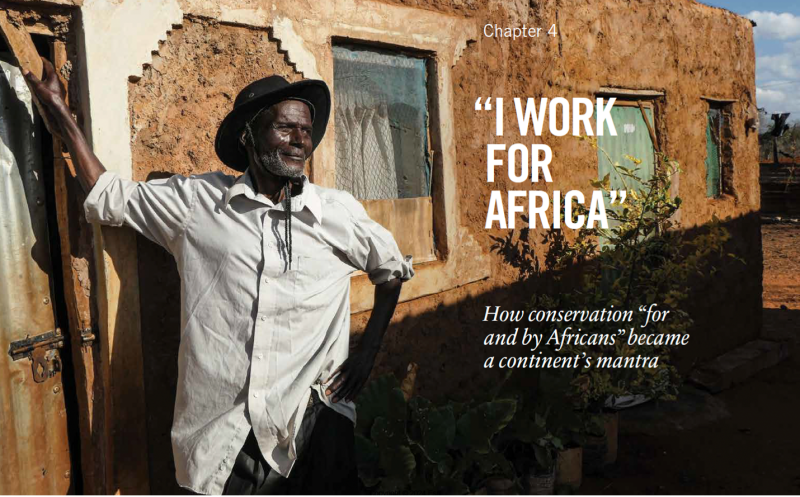
“These stories also connect to larger themes like colonialism and the tension between development and conservation. They highlight the essential role of local agency in environmental stewardship. If we are to achieve our ‘30x30’ goals, we must get Africa right,” Yarnold shares in the interview.
While many stories focus on the efforts of governments and nonprofits, Yarnold also examines how businesses leverage GIS to transform industries. A compelling example arises from the insurance sector, where he discusses a proposal to create high-quality images of every non-military inch of the U.S.
“My first thought was: ‘Wait, you want to do what!’ That became a prime example of how GIS is reshaping the insurance industry, from Lloyd’s of London to Silicon Valley startups. It also led to stories about how companies like FedEx, Nike, and Chick-fil-A are using GIS to revolutionize their operations,” he reflects.
Although these stories may seem less dramatic, they reveal the impact GIS has on business innovation and economic growth.
The final chapter delves into the vibrant world of GIS in UK schools. Yarnold invites us into Nick Whittingham’s lively classroom in Bromley, filled with bright young minds discovering the transformative power of GIS technology. As these 13-year-old girls eagerly explore geographic features like Ben Nevis, the highest point in the U.K., they embody a new generation ready to leverage GIS for meaningful change.
The narrative extends beyond classrooms, introducing young professionals harnessing GIS technology to tackle pressing social issues. This again underscores the book’s central theme – GIS is not merely about tools and techniques; it fundamentally revolves around the people who wield it and the profound impacts they can have on their communities.
The book explores a variety of GIS applications in other chapters, with Yarnold’s journalistic instincts shining through each. The Geography of Hope is a masterclass in storytelling, weaving together complex technology and human narratives to illustrate how GIS is quietly shaping the world around us.
Yet, Yarnold doesn’t shy away from addressing the ethical concerns surrounding data and technology. He discusses the risks of data privacy violations, particularly in national security contexts, where the lines between public safety and state surveillance can get dangerously blurred.
The book’s strength lies in its ability to make the technical aspects of GIS accessible to a general audience without sacrificing depth. Another compelling aspect is the optimism that runs through. Yarnold introduces us to a community of innovators and visionaries who see the world’s challenges as opportunities for growth and improvement. The Geography of Hope argues that, when used responsibly, technology can be a force for good, capable of creating fairer, healthier, and more sustainable societies.
The Geography of Hope is published by Esri, and now available on Amazon.