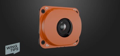
Wingtra announced a new mapping sensor, the MAP61, designed for both large-scale 2D mapping and high-resolution 3D models. With this release, Wingtra enables mapping professionals to capture faster than ever, as well as single-pass 3D detail capture for analyzing vertical assets. Regarding efficiency, Wingtra claims that up to 460 ha (1140 ac) can be captured in a single flight at 120 m (400 ft), with a 60% image overlap.
Product specifications
An online spec sheet includes all important metrics of the sensor: the MAP61 offers a 61 megapixel full-frame sensor with 17 mm lens and low oblique configuration. Regarding accuracy, a horizontal absolute accuracy of 2cm (0.8 in) can be achieved using PPK, and a vertical absolute accuracy of 4cm (1.6 in). The lowest possible GSD is 1.2cm/pixel (0.47 in/pixel). A horizontal 93° field of view enables covering more ground in fewer images, which reduces flight and processing time.
Sensor comparison
Compared with other Wingtra sensors such as the RGB61 and Sony a6100, the MAP61 does not offer the accuracy metrics and GSD size of the RGB61, but is similar to the Sony a6100. Regarding oblique capabilities, the MAP61 offers a lower GSD than the Oblique Sony a6100 3D mapping camera and almost twice the maximum coverage of that camera (460 ha – 240 ha). An overview of all capabilities of Wingtra’s drone sensors is found on this page.
Additionally, Wingtra published a short video announcing the new mapping sensor. It shows a Wingtra drone in action with the payload, as well as some of the datasets created from the captured imagery. It explains in detail how it merges the capabilities of other Wingtra sensors and which sensor is the best choice for a particular use case. For example, the MAP61 may not be the first choice for acquiring survey-grade accuracy data, but offers larger coverage than the RGB61.
Intended use cases and datasets
The MAP61 is meant for use cases such as land management (capturing parcel boundaries), mining (remote surveying for high-res 3D models), urban planning (high-res 3D twin creation), and more. To show what the MAP61 is capable of, Wingtra published several datasets on the mapping sensor’s product page. These are accessed directly from a browser so you can zoom in and study the details of the outputs.
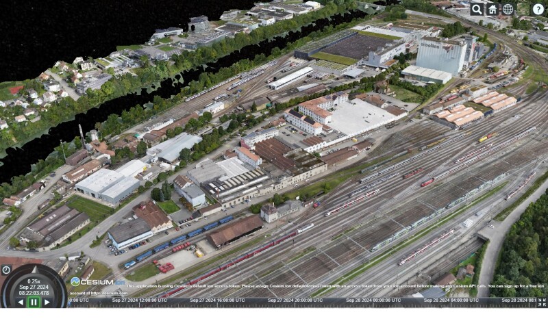
The datasets include a railway digital twin (3D mesh) covering 320 acres, a building inventory for a 3D cadaster (103 acres), available in 2D and 3D, and more. One specific dataset of a golf course map was captured in just 37 minutes with the MAP61 sensor, covering 270 ha (670 ac) at 120m (400 ft), which gives an idea of flight times in combination with area coverage and flight height.