Ordering Earth observation imagery is challenging because of the fragmented nature of the data ecosystem. Different competing data providers offer a wide range of products and services. Customers deal with multiple (subscription) contracts, user interfaces with different ordering and tracking processes as well as pricing schemes. Data providers will also have different APIs, which is challenging for geospatial developers when automating data access.
UP42 wants to change this situation with a geospatial platform and marketplace that sits at the center of an ecosystem of partnerships. UP42’s platform simplifies data access, streamlines data management, and empowers imagery processing for seamless downstream integrations. The platform also provides data management and processing capabilities.
UP42’s main value proposition
UP42’s main value proposition is providing a single touch point to get over 140+ Earth observation data collections. Maintaining a connection with many data providers in such a dynamic industry would be difficult for any company. UP42’s platform also simplifies the data ordering process, regardless of the data providers. Offering visibility into pricing is another differentiator, whether it’s for ordering archive data or placing tasking orders.
There are different ways to interact with UP42. A robust API lets geospatial developers leverage processes such as discovering archive data, placing tasking orders, or monitoring tasking orders. This can be done with an API and Python SDK that simplifies even more of the complexities of API calls, such as building JSON payloads.
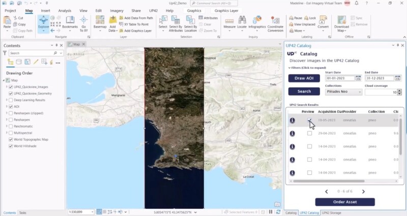
UP42’s ArcGIS Pro plugin
Yet another way to interact with UP42 is an Esri add-in for ArcGIS Pro, a bridge between ArcGIS and the user’s UP42 account with all user credits. The add-in enables ArcGIS Pro users to add Earth observation from UP42’s platform to their mapping projects. How this works was demonstrated in a webinar from both companies.
The plugin offers a simple workflow for organizations to insert commercial raster imagery into their GIS projects. For example, the plugin features a “Draw AOI” button that lets users draw a box around an area of interest (AOI) on a map that can be filled with raster imagery from the UP42 catalog. So instead of ordering fixed quantities of satellite imagery, you only pay for what you need, which is the defined AOI on the map.
The add-in has a Catalog icon that lets you search for available imagery directly, based on search parameters such as start and ending dates, cloud percentage, and constellation. You can directly preview the data on the map before ordering it from the UP42 platform.
Using the imagery for further analysis
The added imagery is more than just a visual enhancement of the area of interest. For example, GIS users can leverage Pro’s raster functions to run analysis functions on the raster data, such as the NDVI raster function to detect relative biomass (greenness) in a raster image. The webinar features an example of how to perform automated feature extraction on the added imagery, by running a pre-trained model to extract all swimming pools, cars, and solar panels in the available image. These are added to the map as vector features. Pro’s Swipe tool lets you perform a visual inspection to see how accurate the results of the pre-trained feature extraction tools are, by comparing the vector features created from the model with the raster imagery.