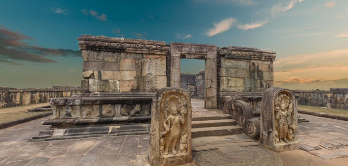
Laser scanners and digital cameras for surveys generates massive 3D datasets with millions of data points and large photorealistic textures. To address the challenge of getting usable information out of that massive amount of data, Twinsity uses its “cutting-edge visualization software” to allow users to interactively explore, collaborate, and share high-quality and photorealistic 3D projects.
Designed for surveyors, architects, and inspection teams, Twinsity is available in two versions: the Studio and the Viewer. The Studio version allows users to import 3D photogrammetry and laser scanned mesh models and work directly on and with them. Within the software, users can move intuitively, with smooth movements, through the digital twin (even in VR), take highly detailed measurements, create annotations, and record videos to create visually appealing animations. Additionally, Twinsity Studio’s projects can be easily exported to the 100% free and unlimited Twinsity Viewer, which allows clients to view existing Twinsity projects and take full advantage of all features, including measurements, annotations, and recordings.
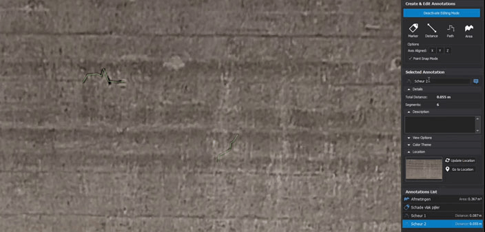
From cultural heritage to the architecture sector or inspections, Twinsity can be a useful tool in many sectors. For example, during the restoration of a railway bridge in the city of Nijmegen, GeoZICHT, a drone service provider in the Netherlands, used Twinsity to carry out detailed and accurate inspections of the concrete structure. After taking 2500 photos of the structure with a drone, GeoZICHT processed the information through Twinsity and, by navigating the 3D model with the software’s first-person mode, discovered interesting regions that would have been completely inaccessible for a manned inspection. Since those difficult areas were easily accessible digitally, Twinsity helped the company to save money and time on expensive scaffolding that could become necessary as an alternative.
“Twinsity proved to be the best tool for this job as it is able to render the full texture resolution in a smooth 3D environment, with the ability to add annotations directly onto the mesh and using the high fidelity of the model to accurately measure small deformations of the concrete,” said Jasper Mink from GeoZICHT.
Especially while mitigating challenges presented by a global pandemic, Twinsity can help to maintain work processes that would otherwise standstill due to limited travel opportunities. For example, it is no longer necessary to be physically on-site for an inspection. Instead, you can work digitally and in the highest quality with the recorded models, saving time and money.
Founded in December 2019 after years of development, Twinsity is currently running an extensive Early Adopter program to further refine current features and integrate new ones. The software was developed after co-founders Uwe and Fabien Chalas, former co-founders and CTO of the German UAV company Aibotix who know the surveying and inspection industry well, saw the unused potential of collected 3D data, which is usually wasted with 2D floor plans and orthophotos. That’s when they saw the chance to offer the AEC industry the digital reality tools they need to make inspections fast and collaborative.
“We developed our software Twinsity completely from scratch with a special focus on the best performance and high fidelity. That’s exactly our USP: to make it possible to view your really big digital twins as 3D models with hundreds of millions of polygons,” Fabien Chalas told SPAR 3D. “Our platform is like ´Google Earth on steroids´. The opportunity that we saw was combining the professional industries (capturing reality data like digital twins) with state-of-the-art gaming technologies to produce interactive and immersive virtual visits of real places all over the world.”

To further enhance its solution’s capabilities, Twinsity is currently working on new features set to release later this year or early next year, such as CAD design integration, TwinSpections, cloud collaboration, and an online viewer:
- The CAD integration merges reality capture projects and 3D CAD design models, making design reviews more realistic and intuitive. For example, architects will get a more immersive way to present architectural designs when integrating them into the context of the environment, streamlining stakeholders’ decision-making processes.
- Twinspections allows users to click on any spot in the 3D model and get the corresponding images in which this spot is visible. This way, the 3D model inside Twinsity becomes a smart navigation tool for large imagery datasets. This saves a lot of time when searching the images for potential issues, as they can be identified and located much faster in the 3D model.
- The Cloud Collaboration feature will allow teams to store and access projects in Twinsity’s cloud, where anyone from the team can edit, inspect, and receive instant updates and notifications about any changes.
- The Online Viewer will allow users to publish reality capture projects into a web-based Viewer, and share a generated URL with their clients to give them access to the project in the cloud. The viewer will work with web browsers, smartphones and tablets.
Starting this month, Twinsity’s licenses are available with different models at Early Bird prices, providing full access to the fully-featured application, free updates, and technical support. When purchasing a runtime license, users can use the EarlyBird2020 coupon to take 20% off. The company also offers a 30-day trial with access to all Twinsity’s features without any limitations.


