Worldwide forestry monitoring just latest in suite of forestry products
CORK, Ireland – Treemetrics, founded with the idea of using laser scan data to more accurately count and catalog forests around the world, has landed this week a $1 million deal with the European Space Agency to use satellite data in combination with their proprietary software and terrestrial laser scanning to monitor forests the world over.
“It will allow forest owners to do forest monitoring from the comfort of their homes and offices,” said Treemetrics CEO Enda Keane. Called SatForest 3D, the new product will make it “so they can do their own analysis,” he said, “and they don’t need a complex GIS system. It can just be done with our software as a service online.”
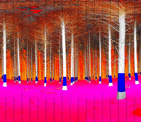
The new product is an extension of the core and initial offering, Autostem Forest, which allows any forest owner around the world to upload scan data and get back the ability to interrogate their trees, figuring out what the individual trees are worth. After some fits and starts (we last checked in with them in February of last year), the process is starting to become accepted and valued by what’s a very conservative industry Keane said.
“We’re becoming a kind of data exchange,” said Keane. “The grower scans the forest, and the data is sent to us, and we process it. Then we make it available in the Forest Warehouse, where they get a 3D viewer and they can color code the logs and cut the trees and forest and plots in many different ways and figure out what the best way to optimize the lot is. So, instead of driving around the country, they can just sit there and select the different prices and logs and it’s a valuation tool. Forest owners can now help their buyers better map the timber and they cut out the costs of timber appraisal.”
A few months ago they added onto that another product, which is a real-time tracking of the harvesting machine. Every log that’s cut is fed back with GPS into the web application, and you can track the tree harvesting in real time.
But it all starts with the laser scanner, Keane said.
“The laser scanner is a beautiful piece of kit,” he said. “It’s just incredible data. And the foresters are able to work with the raw data so quickly, so easily. They’ve been using the same tools for a hundred years, so you really have to convince them to put that tool down.” He said the simplicity of the scanner, and the fact that all the trees are georeferenced, makes the data trusted and independent of any opinion, which has been a bane of the industry for years.
“It used to be,” Keane said, “a forest owner in Helsinki, his plot might be 400 km away, and he has to trust a local person to measure that forest,” who’s using calipers and then his eye. “A forester on the ground would say that because of the straightness of the tree he thinks it’s worth a certain amount, but now it’s totally independent and that’s what distinguishes us. It’s a machine that can be audited and trusted.”
Right now, Treemetrics is suggesting that forest owners reach out to local surveyors and engineering firms to collect the data for them, but Keane thinks the scanners will start to be worthwhile investments outright for most forest owners.
“I don’t think scanner manufacturers realize the scale of the market that we’re creating with terrestrial sensors,” Keane said. “It’s a massive, massive industry, a multi-billion-dollar industry. It’s only a matter of time before 3d scanners really become the standard in how forests are measured and utilized.”
“We’ve been in deep R&D and it’s roll out time,” he continued, expanding on his message to the 3D data capture industry, “and we’re going to come calling about doing business together and we think we’ve created a huge opportunity for the scanning community. We’re still alive, and we’re not crazy, and we can make a big impact on the global forest industry.”


