Sponsored by Tetra Tech
In an era where infrastructure serves as the backbone of our communities, Tetra Tech has emerged as a leader in geospatial services specifically tailored for facilities, utilities, and infrastructure projects. Our commitment to leveraging cutting-edge technologies ensures our clients receive not just data, but also actionable insights that drive efficiency, sustainability, and informed decision-making. As we navigate the complexities of modern infrastructure, we remain dedicated to empowering our clients with the tools they need to succeed.
At the core of our offerings is a comprehensive suite of geospatial services designed to address the unique challenges faced by facilities and utility management professionals. Our team specializes in creating precision-engineering scale maps and topographic contours, ensuring every deliverable meets client specifications and integrates seamlessly into existing operational frameworks. This attention to detail is critical for clients who rely on accurate data for planning, construction, and maintenance activities.
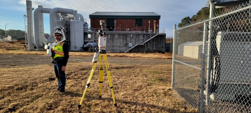
Advanced LiDAR Technology and Innovative Data Solutions – Tinker Air Force Base
Our approach to geospatial services is characterized by the integration of multiple technologies, allowing us to provide a holistic view of facilities and utilities. Our skilled LiDAR analysts excel in feature extraction and data integration, combining photogrammetry with LiDAR to create detailed models of infrastructure. LiDAR technology enables us to capture the intricacies of the built environment with remarkable accuracy. This capability is essential for clients in construction, maintenance, and asset management, as it provides a rich dataset that informs critical decisions related to upgrades and new developments.
To illustrate the effectiveness of our LiDAR capabilities, Tetra Tech conducted a 3D reality case study at Tinker Air Force Base. This study aimed to explore the challenges of reality capture and assess various forms of data collection solutions available in the market. The case study compared workflows and results from a photogrammetric point cloud generated by a 360° camera, alongside point clouds collected from both a mobile LiDAR backpack and a high-accuracy terrestrial laser scanner. The findings revealed that while high-accuracy data collection using LiDAR can be time-consuming, it offers superior resolution, accuracy, and image quality for specific modeling applications. This reinforces the value of our LiDAR technology in providing precise data for critical assessments.
LiDAR’s versatility allows us to gather data from various platforms, including airborne, mobile, and terrestrial systems. This flexibility ensures we can tailor our data collection methods to meet the needs of each project. For instance, our mobile LiDAR technology collects over two million data points per second while providing simultaneous 360-degree imagery. This efficiency accelerates project timelines and enhances the quality of the data collected, making it ideal for applications such as road condition assessments, asset management, and facility planning.
Moreover, we have effectively utilized LiDAR to capture both the interiors and exteriors of buildings, assisting our designers in creating models for building rehabilitation design. This data is invaluable for our space management consultants, who implement workspace management software solutions that improve our clients' understanding of space issues. By developing updated standards and policies regarding space utilization, we provide objective data that supports funding advocacy for building renovations or operational consolidations.
In addition to our advanced LiDAR capabilities, Tetra Tech owns a suite of simultaneous localization and mapping (SLAM) scanners from leading companies such as NavVis and Leica. These state-of-the-art tools enhance our ability to gather precise spatial data in complex environments. Furthermore, we utilize FusionMap®, a cutting-edge web-based data viewing and manipulation platform that integrates artificial intelligence and GIS capabilities. FusionMap® allows us to create digital twins of buildings and infrastructure—virtual replicas of physical assets that can be used for simulation, analysis, and optimization. By helping our clients navigate the evolving landscape of machine learning, artificial intelligence, and virtual and augmented reality, Tetra Tech ensures they are equipped with the most innovative solutions for effective facilities and utility management.
Mapping and Orthoimagery
One of our key services is the production of high-quality orthoimagery, which serves as a reliable basemap for visual interpretation and engineering design. By using digital cameras and satellite imagery, we provide clients with a solid foundation for further analysis. Our orthoimagery is particularly useful for utility companies and facility managers who need to assess existing conditions and plan for future developments. The clarity and precision of our imagery allow for effective communication among stakeholders, facilitating better decision making throughout the project life cycle.
UAV-Based Magnetometry for Infrastructure Inspection
In addition to traditional geospatial services, Tetra Tech employs UAV-based magnetometry for infrastructure inspection, which is particularly effective in detecting buried utilities and identifying structural defects. This technology allows us to conduct noninvasive surveys that reveal critical information about underground assets, helping clients avoid costly disruptions during construction and maintenance activities. By integrating magnetometry with other geospatial capabilities, we provide a comprehensive solution that enhances the safety and efficiency of infrastructure projects.
Moreover, our expertise in magnetometry extends to explosive ordnance disposal (EOD) projects, where it plays a crucial role in identifying buried munitions and ensuring safe site conditions. By using advanced geophysical techniques, we can accurately locate and assess potential threats, providing our clients with the confidence they need to proceed with their operations safely.
Integrating Multispectral and Hyperspectral Imagery
In addition to lidar and magnetometry, Tetra Tech uses multispectral and hyperspectral imagery to conduct comprehensive studies in agriculture, environmental science, and geology. These technologies allow us to analyze vast portions of the electromagnetic spectrum, providing insights that are crucial for effective utility management and infrastructure planning. For example, our hyperspectral analysis can identify vegetation health, soil composition, and water quality, enabling utilities to make informed decisions about resource management and environmental compliance.
Mobile Mapping for Efficient Data Collection
The need for rapid data collection in today’s fast-paced world cannot be overstated. Our mobile mapping technology exemplifies this need, allowing us to gather high-precision data at posted roadway speeds. This capability significantly reduces the time and costs associated with traditional survey methods, enabling clients to complete projects more efficiently. By leveraging machine learning algorithms, we can automate the extraction of asset information, drastically reducing the time and resources required for manual data processing. This automation enhances efficiency and ensures the data is formatted to meet the needs of various end-user software applications.
Collaboration and Client-Centric Approach – UK Nuclear Facility
Tetra Tech’s commitment to innovation is matched by our dedication to client success. We understand that every facility and utility project is unique, and we take the time to listen to our clients’ needs and challenges. This collaborative approach allows us to customize our services, ensuring we deliver solutions that are effective and aligned with our clients’ strategic goals. Our team of ASPRS-certified photogrammetrists, FAA-certified UAS pilots, and GISP-certified GIS professionals work together, bringing a wealth of knowledge and experience to every project.
A notable example of our client-centric philosophy is our work with a secure nuclear facility in the United Kingdom. Tetra Tech UK was contracted to create 3D models and floor plans, which required strict protocols for scanning and managing geospatial data. We utilized various survey instruments, including total stations for single-point capture, laser scanners for millions of points, and 360° cameras for panoramic imagery. The data was processed on air-gapped machines to ensure security, and the client chose to display the results using ESRI ArcGIS Indoors, hosted on-premises with ESRI’s Enterprise solution.
Our client-centric philosophy extends beyond project execution; we strive to build long-lasting relationships grounded in trust and transparency. By maintaining open lines of communication, we ensure our clients are informed and engaged throughout the project lifecycle. This partnership approach fosters a sense of shared ownership and accountability, ultimately leading to more successful outcomes.
Future-Ready Solutions for Sustainable Infrastructure
As we look to the future, Tetra Tech remains steadfast in our mission to provide integrated geospatial solutions that drive sustainable outcomes for facilities and utilities. Our extensive experience managing geospatial data for utility systems across the U.S. has positioned us as a trusted partner in the industry. We take pride in our ability to adapt to changing technologies and evolving client needs, ensuring we remain at the forefront of geospatial innovation.
Our services are designed to meet current demands and anticipate future challenges. By investing in research and development, we continuously enhance our capabilities, enabling us to offer cutting-edge solutions that address the complexities of modern infrastructure. Whether it’s through advanced data analytics, predictive modeling, or real-time monitoring, Tetra Tech is committed to helping our clients navigate the ever-changing landscape of facilities and utility management.
Tetra Tech is more than just a provider of geospatial services; we are a partner in your journey toward effective facilities and utility management. Our innovative solutions, combined with our dedication to client success, empower you to navigate the complexities of modern infrastructure. Together, we can harness the power of geospatial data to create resilient, efficient, and sustainable facilities and utilities that serve our communities for generations to come. With Tetra Tech by your side, you can be confident you are equipped with the insights and tools necessary to thrive in an increasingly data-driven world.
![]()