Whiteout Solutions is a geospatial technology company based in northeastern Vermont, USA. The company provides end-to-end geospatial solutions and specializes in UAS topographic bathymetric lidar, and hyperspectral and multispectral imagery. Over time, the company transitioned from topographic lidar data collection to more specific projects requiring topographic bathymetric lidar data.
Collecting bathymetric data
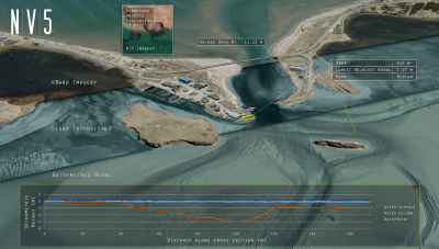
Bathymetric data provides detailed information about underwater depths and topography and is collected using various methods including sonar and lidar. Bathymetric lidar is a type of lidar that allows for the collection of surfaces and objects below water, up to a certain depth. The penetration of bathymetric lidar is variable because water turbidity varies in different types of water.
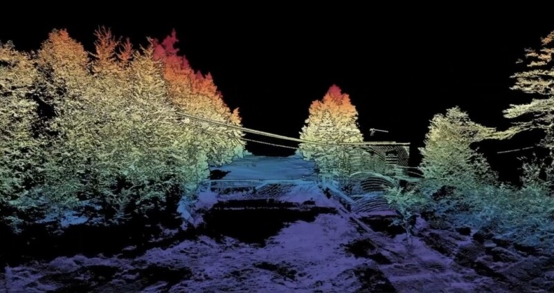
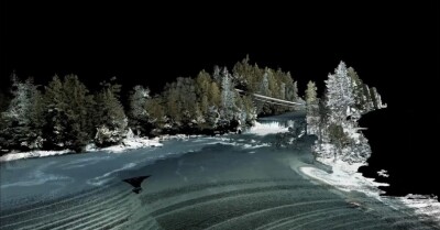
Today, drone-based bathymetric lidar is a popular technology for collecting and analyzing wetlands, dams, river corridors, coastal erosion, and riverine. Being much safer and quicker to deploy than traditional survey methods, it has become a popular technology in surveying. One of the reasons for this is that UAV bathymetric lidar can collect both topographic and bathymetric, such as the shoreline of a river. The topographic data provides a geographical context for the bathymetric data.
Mapping riverine and coastal environments
Whiteout Solutions acquired its first topographic bathymetric lidar sensor in 2023 when the company was contracted to map all of Connecticut’s protected coastal marshlands. This decision was motivated by the fact that although topographic lidar alone was very effective, it did not provide the entire picture as microtopography and channels were lacking.
Today, Whiteout Solutions uses bathymetric lidar for various use cases, including mapping riverine, wetlands, and coastal environments. Drones allow highly targeted surveys of hard-to-reach areas, such as riverine environments. Manned aircraft are also hard to maneuver in narrow waterways, whereas drones can fly a straight, pre-defined flight path automatically.
Using drones for mapping wetlands enables the company to cut down on the number of people needed on the ground, and collect topographic and bathymetric data simultaneously. The company also uses UAV bathymetric lidar for mapping intercoastal highways, near-shore coast, and submerged manmade objects.
RIEGL topobathymetric sensor and UAV integration
Whiteout Solutions uses a RIEGL VQ-840-GL topobathymetric sensor for mapping riverine and coastal environments. The scanner carries out laser range measurements for high-resolution surveying of underwater topography with a narrow, visible green laser beam, emitted from a pulsed laser source. Typical applications include coastline and shallow water mapping, surveying for hydraulic engineering, hydro-archeological-surveying, river surveying, and repeated survey of water reservoirs.
The VP-840-GL uses a nearly elliptic scan pattern, a preferred scanning pattern for detailed and efficient underwater mapping due to benefits such as increased coverage, uniform data distribution, adaptability, and high resolution. The sensor has been successfully integrated with a Harris Aerial Carrier H6 HL, a heavy lift drone with a flight time of around 30 – 40 minutes, depending on environmental conditions.
Access the entire webinar titled “Beyond the Surface: RIEGL Bathymetric LiDAR & Whiteout Solutions for Riverine & Coastal Environments” here.