There isn’t a corner of the globe in which climate change has not had some effect. These effects manifest in different ways and to different severities, and the exact level of impact climate change has on certain events varies from case to case, but it is a truly global problem that requires monitoring and studying. Some of these projects are to hopefully mitigate these problems, while others are simply to understand the scope of a problem and help local communities adjust. Regardless of the exact purpose, as we cover here at Geo Week News regularly, geospatial tools are often a crucial piece of these efforts.
A recent example of this kind of work took place in the Rwenzori Mountains along the border of Uganda and the Democratic Republic of Congo. Led by an organization called Project Pressure, a group of scientists and locals climbed to the peak of Mt. Speke, Mt. Stanley, and Mt. Baker to create the first-ever 3D maps of the glaciers atop these mountains, glaciers that serve as an important part of the hydrological ecosystem of the area as well as playing an important cultural role for the local communities. Geo Week News recently spoke with Klaus Thymann, Project Pressure’s founder and a self-described scientist and explorer, about how this project worked, what they found, and how they are hoping their findings will be used in the future.
It’s worth starting with Project Pressure itself and the goals behind this organization, which was founded in 2008. The original idea was doing something to address the growing climate crisis, and he said they were looking to find a way to communicate these concerns without lingering in “some gray area.” He noted that things like wildfires, flooding, and other similar events certainly tie back to climate change, but it’s not 100 percent attributed to this. So, they chose a more specific focus.
“Long-term glacial recession is happening because of warming trends. That is happening because of climate change, and nothing else. Therefore, it seemed like an idea that we could communicate about climate change in a way, using glacier recession as a communication tool.”
For this project, Thymann traveled to these mountains to monitor tropical glaciers, a crucial part of the local ecosystem but not necessarily the priority for most climate change-related projects, where glaciers are more commonly studied in arctic regions like Greenland and Iceland. Thymann and his team have made this trip multiple times over the last decade-plus, originally with the hope of creating a baseline record ahead of potentially reversing trends and now documenting the recession of these tropical glaciers over time.
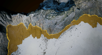
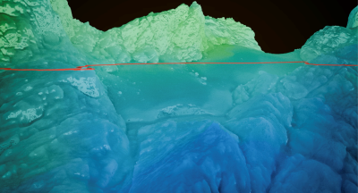
This particular iteration of the project was particularly notable because it was the first time they created 3D maps of these peaks. Thymann noted that Trimble was one of the reasons they were able to complete this work, due to both their hardware in the form of the Catalyst GNSS positioning service as well as their team assisting with the processing of the imagery to create a photogrammetric model.
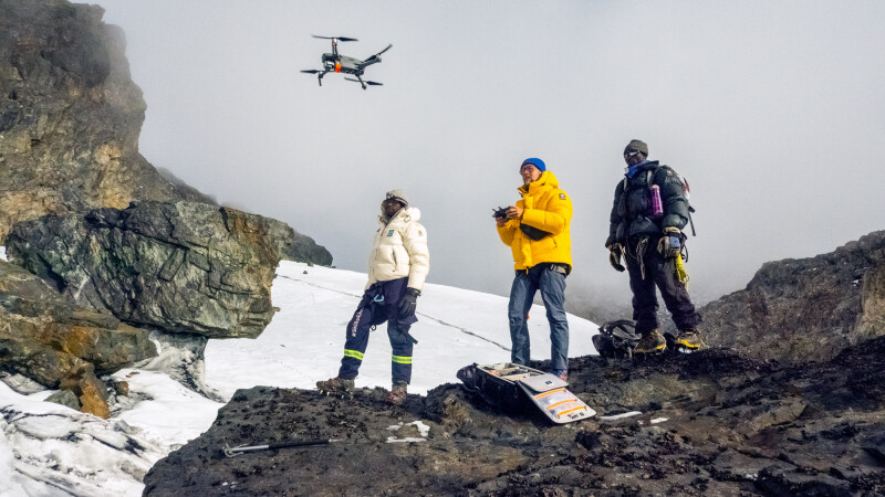
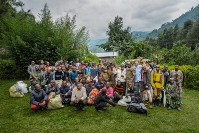
Thymann told Geo Week News that there is no way to get to these peaks other than trekking, as they are not accessible via vehicles like cars or motorbikes. Thymann and a team including people from the Uganda Wildlife Authority and others in the local Bakonzo community – “We try to work as much as we can with the local communities instead of flying people in who aren’t from there,” Thymann told Geo Week News – carried the equipment in backpacks to the peaks.
Once up there, the researchers started collecting the data, which would ultimately create the base of these models. Most of that was collected via drone imagery, which was georeferenced using 10 ground control points around the area that were georeferenced using the aforementioned Trimble Catalyst. They were also joined on this journey by Heïdi Sevestre, a glaciologist and specialist in ground-penetrating radar (GPR), who collected GPR data around the glacier.
Ultimately, what they found at these peaks was disheartening, though perhaps not particularly surprising. On both Mt. Speke and Mt. Baker, there is no more glacier; for the former, there is still ice, but with no movement, while on Mt. Baker, there is no ice at all. On Mt. Stanley, they report that the glaciers are becoming fragmented, and that compared to 2020, the area of the Stanley Plateau glacier has reduced by nearly 30 percent.
When asked what the ultimate goal of collecting this data is, Thymann points to a few different potential uses. The first is to simply create a virtual record of what was once there.
“It sounds really sad, but at some point soon there won’t be any ice there. The only thing we will have is a virtual record. In some ways, it’s the visual Noah’s Ark of the glacier, and it’s just to create a nice legacy so at least future generations will have something that’s a visual archive, but it’s also embedded with data.”
More important in his mind, though, is getting this data into the hands of the local communities who are most affected by this loss of ice.
“The people on the ground, they live off the ice. It’s a part of the hydrological system. If they don’t know what’s going on, they can’t plan. For them, getting accurate data on what will actually happen in the coming years will help them adapt. These communities are not the ones who have caused climate change, but they’re the ones who are living with the consequences.”
In addition to the importance of these glaciers to the way of life for the Bakonzo people, it should also be noted that the glaciers hold tremendous cultural importance as well, as they are believed to be the home of their god, Kithasamba.
In a statement, Uganda Wildlife Authority’s Alfred Masereka said, “The Bakonzo people who live among the mountains are strong people who believe that the mountain is a very important aspect of their life. The disappearance of the ice is bad news because it means our gods are being destroyed.”
Looking forward, Thymann and Project Pressure have set up systems to continue monitoring this area, and crucially keep the Bakonzo people involved in this effort.
“We put up a few time-lapse cameras, and locals can go and collect the memory cards and ship them to us. Then we can start seeing what’s happening,” Thymann said. “It’s a good collaboration of simple technology, having a baseline that works, and letting people on the ground do what they can do.”
He said that this kind of method with strategically located time-lapse cameras has not been tested before, but they hope it will help them create an ongoing 3D model that is less laborious to create than with drone imagery.
Thymann also indicated that Project Pressure is also interested in doing similar work with other tropical glaciers, specifically in Indonesia. Ultimately, he acknowledged, these are complex problems that require complex work, but it all starts with this kind of mapping.
“We have a lot of things that can seem overwhelming, and there are big issues with big questions. But also, when you break it down, a lot of the starting point has to be maps. Without maps, we can’t navigate. That was true for seafarers, it’s true for anyone who’s trying to get from Point A to Point B. But it’s also true for science.”