There are a lot of similarities between the construction and commercial marine industries, with both being relatively blue-collar in nature, both serving as some of the oldest and most established industries in the world, and more recently, with both owning a reputation for being averse to technology. Those reputations can often be overblown, though, and leaders in each sector are adopting cutting-edge solutions to assist workflows in what are often complex environments. Ports, in particular, have a lot of moving pieces and stakeholders all interacting simultaneously, making it the perfect place to test some of the most innovative solutions.
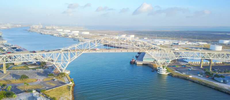
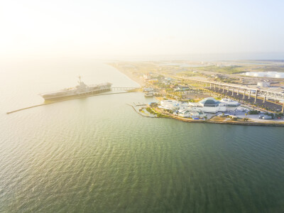
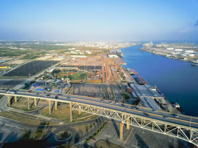
This is exactly what is happening at the Port of Corpus Christi in Texas, one of the largest liquids-based ports in the world, and the leading port for crude oil in the Western Hemisphere, according to Darrell Keach. The business systems manager for the port, Keach recently spoke with Geo Week News about a new initiative with the port, combining Esri’s GIS capabilities, their connection with Unity, imagery, and other data to create a digital twin of the port.
In speaking with Keach, it’s clear that one of the keys to making this digital twin creation successful, at least in these still early stages, was having a defined utilization from the start. He noted that the Port of Corpus Christi, contrary to the industry’s reputation, embraces new technologies and was looking to modernize operations. Their big question, in his eyes, was: “How can we leverage our data better? We know we’re sitting on a lot of data, but it’s all siloed in different systems, or we’re just not making use of it.”
This was just a couple of years ago, but a time when digital twins were just getting out of a buzzword kind of stage and organizations were looking to implement them for their workflows. Keach pointed out that many organizations failed to launch their digital twin, and the Port did not want to make the same mistakes.
“It was a failure to launch [for other organizations] because it wasn’t defined specifically. A lot of people say, Yeah, we’re going to create a digital twin. And then the follow-up question of, to do what, and for most people that’s where it falls apart.”
Instead, the Port of Corpus Christi went in with a clear plan for their digital twin, allowing it to get beyond the planning stages and start to provide tangible value. They were able to get funding for the creation through a grant awarded by the Department of Homeland Security, through FEMA and the Coast Guard, and with that funding, they initially focused on creating the digital twin to boost their security and law enforcement operations. With that clear vision of what they were building and, more importantly, why they were building it, they were able to create the digital twin within a year.
The Port was already an existing Esri user, so it made sense for them to start with the base map data provided within the Esri ecosystem, and utilize the company’s SDK with Unity. Partnering with The Acceleration Agency, who has decades of experience using gaming technology including Unity’s and a shell of an application that could be retooled for these purposes, they got to work combining the Esri data into a 3D system to create the virtual representation. That data was supplemented in some areas with high-resolution drone imagery, as well as data from the AIS International Ship Tracking System, which provides real-time tracking data from ships around the world and allowed the port to place 3D models of these ships within the model.
All of this leads to a real-time digital twin, for which Geo Week News saw a demonstration, showing the ships that are coming in and out of the port and monitoring the surrounding areas, which include office buildings, oil tanks, a minor-league baseball park, and more. In the demonstration, the digital twin showed random alerts as would be seen by security personnel in the area, immediately identifying where an emergency – say, a gas leak – is happening, and providing access to optimal cameras in the area, information about all assets within a set radius around the incident, and more.
Keach also told Geo Week News that they are almost finished with a new bridge over the port, and they are able to look virtually from the point of view of the bridge and ships in the port to identify potential security issues that could come from the new location.
This is just the starting point of this digital twin, though, and Keach has many other ideas for how this data can be used moving forward. One example included leveraging virtual reality to help ship captains and crew navigate through heavy fog.
“The port here is affected by sometimes as many as 120 says a year with fog that affects traffic. Conceptually, we’re starting to work out, if we built a digital twin and we’re bringing in all of this various sensor data, could we then take that information and provide that to a vessel to move with limited sight? Or it could be that the captain and crew put on VR goggles so they could visualize the port as they’re going through.”
To that end, the port also recently received funding to build their own private network, ensuring better connection. This is crucial for this digital twin value, as the inclusion of Unity allows for people to see the virtual representation on mobile devices, something that requires strong and consistent connection.
Just sitting through the demonstration, it was clear how much potential this kind of technology usage has for a complex site like a port. Even just bolstering the already impressive security applications, Keach indicated a long-term goal of having the inside of buildings within the port’s jurisdiction scanned in addition to the outdoors to add more information to potential incident reports. He even called out that the digital twin could be used as a sales tool, showing off pieces of property that could be for sale and being able to drop in renderings or simulate environmental factors like weather and sunlight right within the digital twin.
They’re just scratching the surface right now, but Keach reported that there’s nothing but excitement about the possibilities at the port.
“The local people are excited about the possibilities,” he said. “They’re like, Wow, I’ve never seen anything like this. It is really bleeding edge even more than cutting edge.”