

Construction sites are complex environments where builders and managers must maintain a wide range of assets both indoors and outdoors. Monitoring the status of construction tasks, looking for mistakes and defects, and reporting valuable information to crews and leaders is an important – and sometimes arduous – undertaking.
Fortunately, many companies can now better address these issues by integrating modern imaging technologies. One of the leaders in the category of 360° jobsite capture is San Francisco-based OpenSpace.
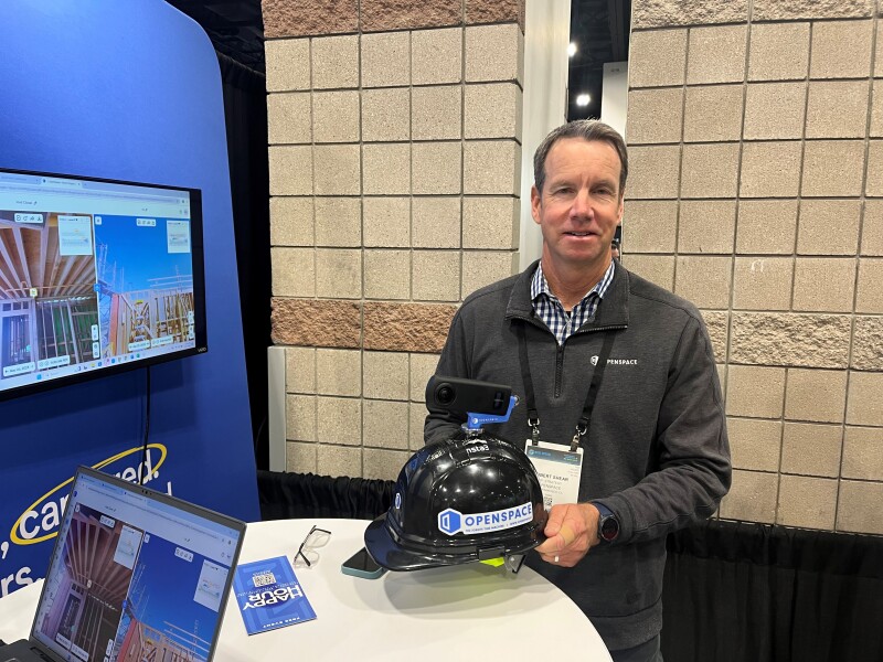
At the recent Geo Week 2025 event in Denver, Geo Week News had the opportunity to speak with Robert Shear, VP of Business Development and Strategy at OpenSpace.
Geo Week News: There are a few companies here at Geo Week that offer solutions for construction industry professionals. Can you explain what OpenSpace does and what makes it different?
Shear: What we do is capture reality, but with an off-the-shelf 360°camera. We primarily serve what you would call “vertical construction” where 95% of the construction happens indoors in GPS-denied environments. On these jobs, you have lots of people involved and multiple things happening. For example, you might have four or five trades, one or more architects, change orders, requests for information—the list goes on! It's a lot and things can get messy and confusing. With our technology, you can capture what’s happening with a 360°camera you can buy for about $400. The process is pretty darn simple. You put the camera on your hard hat, open the OpenSpace mobile app on your phone (or tablet), pull up your site plan to choose your starting position, and tap record. Then you just walk the site (like you normally need to do anyway). As you walk, you're taking 360° images at a low frame rate, which are then uploaded to the cloud for processing and automatically pinned to your plans. What you get is a fully documented record of your site that you can navigate—like Google Street View. It makes it easy for everyone to view the project, enabling better communication and documentation for various stakeholders.
Geo Week News: How have construction industry professionals responded?
Shear: People like the simplicity of the technology. First, all you need is a mobile phone or tablet, a $400 camera, and a site plan. Training is minimal, and users are able to capture and process images in half an hour. The system is designed to be user-friendly, even for those who aren’t tech savvy. We find that the technology is used frequently, with customers capturing images once or twice a week for various purposes, including owner-architect-contractor meetings and confirming payments.
Geo Week News: What kinds of people are using the OpenSpace system? What kinds of work is it best suited for?
Shear: The majority of our user base is construction. And when I say construction, I mean the folks doing the work in the field, like superintendents, project managers, and engineers. For this audience, we're a complementary solution. For example, we’re not replacing a laser scanner which is dimensional, and you’d use to measure half-inch accuracy against a model. What we provide is an easy and fast way to create a visual representation of reality—a tool that enables you to build context and awareness among all the trades, among all the people on the jobsite. Let’s say you have an engineering team in India and a consultant in Cincinnati. They can all pipe into the job from anywhere—you’re bringing the jobsite to the experts, rather than experts traveling to the jobsite.
In this user base, we're seeing interest in having OpenSpace be a way to offer additional services to their clients. They might be scanning a facility maybe once a year or once every couple of years, but with us they can do this every month or every six months, which helps them plan their scanning work. We are an “everyday visual twin”—you can capture as often as you want, making it easy to see and understand what’s happening on a project and how that project has changed over time.
Geo Week News: What’s next for OpenSpace?
Shear: We are looking to expand into industrial applications such as mining, oil and gas, and manufacturing. We also want to position ourselves as a complementary solution to existing laser scanning technology and workflows.


