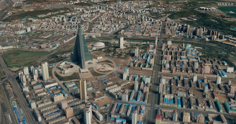
Earlier this month, geospatial intelligence provider Maxar Intelligence announced that they had received a contract to provide a Precision3D Data Suite bundle to the National Geospatial-Intelligence Agency (NGA). The deal provides data to cover 160,000 square kilimoters within the US Indo-Pacific Command area of responsibility, which is the largest of the six geographic combatant commands.
Per the release of the news, the data “will support the work of NGA’s Office of Geomatics, which maintains accurate 3D GEOINT products in support of a diverse group of military and civilian customers.”
The contract ensures the following products will be provided to NGA:
Precision3D predicted accuracy data
The Precision3D data suite, which last year was added to Esri’s Living Atlas of the World, provides accurate views of the Earth in three dimensions build using multiview photogrammetry methods. With the data, users are able to complete informed analysis with accurate insights, run digital simulations, manage resources and prepare for disaster events like floods and landslides, among other use cases. The data suite includes the 3D surface model and digital surface model, both mentioned above, along with a digital terrain model, point clouds, and building vectors for any spot in the world.
Maxar Intelligence is the result of a restructuring Maxar Technologies underwent in September of last year. Following an acquisition by private equity firm Advent International that closed in May of last year, the company split into Maxar Space Infrastructure and Maxar Intelligence. The former oversees manufacturing of spacecraft, whereas the latter – which is the piece of the business that received the NGA contract – is responsible for the satellite imagery side of the company’s offerings.
This contract exemplifies a couple of truisms within the geospatial industry, and really most industries in today’s landscape. One is that partnership between government agencies and private companies is a must. Maxar is certainly no stranger to government work, and it’s clear that their innovations are coveted by NGA to maximize their work. Most often, those innovations come from the private side, giving the public side more time to utilize the tools for the betterment of the nation as a whole.
Additionally, this is just another example of how important 3D data is becoming. Maxar has traditionally been a provider of satellite imagery, which is certainly important on its own. That said, being able to provide that same geospatially accurate information in three dimensions, with the ability to simulate scenarios and get that extra context opens up so much more value. It’s this value that NGA is looking for, and receiving, with this contract.
"Maxar Intelligence is proud to have secured this award to provide the NGA with commercial 3D data, which speaks to the NGA’s strong partnership with industry and the growing business case for utilizing unclassified, high-quality commercial geospatial data to support national security needs," said Susanne Hake, General Manager, U.S. Government, Maxar Intelligence, in a statement. "Precision3D data enhances situational awareness and decision-making, providing a precise, geospatially accurate representation of Earth that not only reflects the terrain in all dimensions but also provides an accurate foundation for additional data sources through georegistration."


