Southeast Asian mapping contract boosts Q2 sales
Geospatial information services firm Intermap Technologies Corp. Monday reported second quarter profit of $200,000, down 75 percent, on revenue of $8.9 million, an 11 percent increase.
The Denver-based company provides high-res, 3D digital surface models, digital terrain models, orthorectified radar images, and color orthorectified radar images of the earth’s surface on demand with its new, cloud-based Orion Platform.
“Our year-to-date financial performance not only shows improved revenue growth, but also includes lower operating expenses, higher bottom line performance, and improved adjusted EBITDA over last year at this time,” said Todd Oseth, Intermap CEO. “It’s clear that our efforts to refocus the business into a solutions-driven company are continuing to pay off.”
For the quarter ended June 30, Intermap reported adjusted EBITDA was $2.2 million, compared to $2.7 million for the same period in 2012. Working capital increased to $4.3 million at June 30, compared to $1.9 million at Dec. 31.
Contract services revenue in the second quarter increased to $7.8 million from $1.6 in the year ago quarter. This quarter’s revenue was generated primarily from a single, $7.4 million contract in Southeast Asia.
Second quarter data licensing revenue decreased to $1.1 million from $6.4 million in the second quarter of 2012, when one significant sale generated $5.2 million in revenue.
As of June 30, Intermap’s contract backlog of $5.3 million consisted of $4.4 million in contract services and $900,000 in data licensing revenue.
Intermap launched in June its Orion Platform, the industry’s first software-driven spatial data platform, which converts and presents all types of geospatial data into a common format for consistent management and delivery of 3D business intelligence applications.
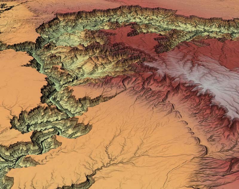
In this colorized shaded-relief digital terrain model (DTM) in 3D perspective, the Colorado River begins its descent into
the Grand Canyon from the lower left and cuts across the Kaibab Plateau as it continues its journey westward to the Gulf of California.
Orion is designed with a common programming interface to give companies and government entities a standard approach to access and manipulate geospatial data in managing infrastructure, weather and related risks, agriculture, excavation, and national security, among other applications, from one unified control point.
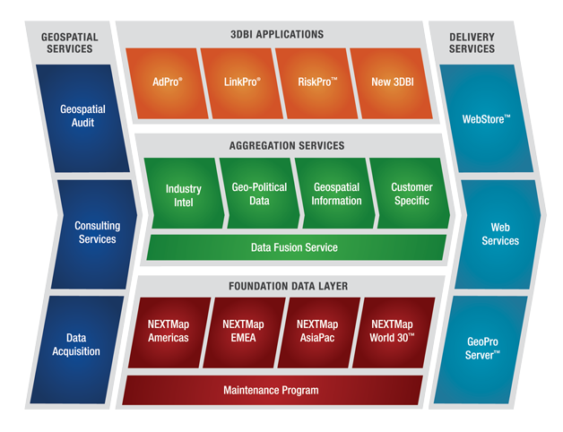
The Orion Platform has five integrated layers:
- Geospatial Services – auditing and custom data collection
- Foundation Data – off-the-shelf, high-resolution elevation data
- Data Fusion – integration of multiple datasets into one homogeneous data specification
- 3DBI – web-based applications for both GIS and non-GIS professionals
- Platform Delivery Services – array of SaaS-based and LAN-based delivery methods
119% jump in expenses
For the second quarter 2013, purchased services and materials expense was $2.7 million, a 119 percent increase, due mainly to an increase in job and subcontractor expenses associated with its airborne radar data collection activities during the quarter.
Purchased services and materials includes aircraft related costs including jet fuel and aircraft maintenance; third-party support services related to the acquisition, processing and editing of its airborne data collection activities; and software expenses.
New $3.5 mil’ mapping contract
Last week, Intermap said it won a $3.5 million airborne mapping contract for hi-res 3D digital models of the earth’s surface aggregated with customer-specific data.
The airborne mapping company said it’s using its proprietary Interferometric Synthetic Aperture Radar (IFSAR) mapping technology on the new project to collect orthorectified radar imagery and hi-res elevation data to update the unnamed customer’s existing geospatial map database.
Final deliveries of the project’s dataset – used for improved disaster planning, resource management, security interests, and infrastructure planning – are slated to be complete by the end of the first quarter 2014.
Intermap creates its own 3D geospatial map products using its IFSAR technology mounted in its two Learjet aircraft. IFSAR allows fast and accurate digital mappfing of large areas, at higher collection speeds, at any time, including overcast and dark conditions.
Multi-sensor data acquisition
Intermap also uses a multi-sensor data acquisition approach, which includes lidar, photogrammetry and satellite imagery, to aggregate data in its NEXTMap database, which includes terrain, elevation and imagery data, 3D city models and flood models, as well as other geospatial related information such as demographics, view sheds, real-time traffic, outdoor advertising assets, weather related hazards, points of interest, and cellular towers.
Once the raw digital map data is collected, it is then processed to create three different NEXTMap 3D digital models: digital surface models, digital terrain models, and orthorectified radar images.
Intermap’s fee- and cloud-based 3D business intelligence (3DBI) applications, including its Pro series of software products, allow the company’s subscribers to access NEXTMap information using their current web browsers and through popular desktop GIS software applications.
Earlier this year, Intermap announced a $14.5 million mapping services contract to provide digital 3D elevation models and imagery for areas in Southeast Asia to serve as foundation data for an updated national spatial data infrastructure to be used for improved disaster planning, resource management, national security interests, infrastructure planning, and the provisioning of new 3D geospatial information applications.
The airborne data acquisition portion of the project started in the first quarter and is slated to wrap up by the end of the year.
Q1 sales up 21%
Intermap reported total revenue of $5.1 million for the first quarter of 2013, which ended March 31, up 21 percent from the same quarter in 2012. It also recorded a $2 million net loss for the first quarter compared to a net loss of $5.1 million for the first quarter of 2012.
2012 revenue was $28 million. A significant portion of Intermap’s revenue is expected to come from customers outside of the United States. During 2012, Intermap had three key customers that accounted for two thirds of total revenue. In 2011, it had four key customers that accounted for about 43 percent of total revenue.


