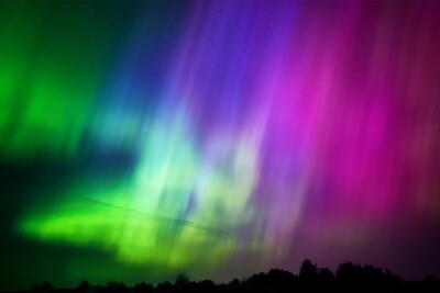
On the weekend of May 11 of this year, people across the United States, as well as other parts of the world, were looking up at the sky for a phenomenon rarely seen in many parts of the country. Typically something you have to travel toward the Arctic Circle to see, the aurora borealis – better known as the Northern Lights – put on a light show in the skies as far south as Alabama with states in the northern half of the country getting incredible views of the natural phenomenon. While not a completely unprecedented event, it’s rare enough to have received extensive news coverage both locally and nationally, and had social media filled to the brim with eye-catching images of the sky.
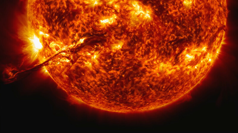
The reason behind these rare views of one of the most beautiful natural happenings on Earth comes down to activity on the Sun. Earth’s star goes through semiregular 11-year cycles of solar activity during which the magnetic poles of the Sun flip during the peak of each cycle. Throughout this time, solar activity fluctuates and we are currently in the midst of what is likely the peak time for this solar cycle. While this particular peak happened to lead to a rare Northern Lights sighting for many around the world, this cycle’s peak isn’t notably strong compared to previous cycles, with measurements for this dating all the way back to the 18th century.
That said, even cycles that aren’t notably strong can have very real effects on Earth’s atmosphere, some of which is visible like the Northern Lights show. Some of it is not visible, however. One of the more notable effects of this increased solar activity is on GNSS satellites. To put it in the simplest terms, during these periods of high solar activity, the Sun is sending extra electromagnetic radiation and other discharge into Earth’s ionosphere. In turn, this added activity within the ionosphere causes delays and other problems with GNSS satellites.
This is something those in the industry are, of course, aware of, and it’s becoming a bigger problem as GNSS becomes a bigger part of different industries. This particular cycle is notable not because of its strength, but because of how industries have changed since the last peak of activity, according to Stuart Riley, Trimble’s Vice President of Technology for GNSS, who recently spoke to Geo Week News about these issues.
Riley has been working in the GNSS industry with Trimble since the mid-1990s, giving him plenty of experience to have seen how the space is changing while also having gone through multiple 11-year solar cycles. In terms of how those cycles work, he relays that areas which are most affected by this disruption are actually dealing with it for about half of the time.
“We see the areas that are most affected start getting affected two, maybe three years before the peak,” he tells Geo Week News. “And then of course, they are affected two or three years beyond the peak. So, we have about six years around the peak when we have a problem, and maybe we have a quiet seven years – so almost 50/50.”
It’s important to note that there are areas which are more affected than others, with the geomagnetic equator (similar, but not the same as the geographic equator) being the worst area. Riley points out that Brazil is right along this equator, and their natural resources make this a significant fact. While there would theoretically be practical effects of GNSS interference for surveyors, since it has the greatest effects at night and surveyors typically work during the day they won’t have the same “instability,” according to Riley.
However, he says, “There are mining companies with 24/7 operations and they are getting hit by this in the evenings and it’s impacting their operations. Similarly, at certain times of the year there are farming operations running 24 hours a day, so it’s hitting their operation.”
Specifically, the interference is affecting productivity for these industries. “Maybe they’ve got some manual processes that they can use to work around it,” Riley says. “But that’s the reason we use GNSS in the first place, after all, is really for productivity. There are other ways you can do some – not all, but some – operations, and GNSS has brought a higher level of productivity to many industries.”
This is really the crux of why this particular solar cycle is getting this kind of attention with respect to GNSS. It’s not that GNSS wasn’t used at all in previous cycles, but there were other problems 11, 22, and 33 years ago. First of all, there were far fewer satellites to begin with, so these 24 hour operations weren’t really happening and surveyors were timing their work with the satellites, and typically doing so during the day.
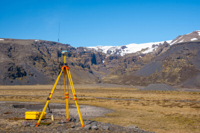
Additionally, GNSS was not nearly as widespread across industry, so sectors like mining and agriculture just weren’t relying so heavily on the technology. Both industries rely on these satellites for things like vehicle navigation and mapping of job sites, along with other use cases, and losing accuracy in these workflows can be extremely costly.
“We have had customers with problems during previous cycles,” Riley notes. “So this isn’t something we’ve been looking at just in the last year or two. We’ve been looking at it through the other cycles, but now it’s just penetrated in these operations more and is increasingly becoming a problem.”
The good news is that this is not a problem without a solution. As Riley said above, this is something that Trimble has been monitoring and working on for quite some time, and late last year they announced their new IonoGuard technology, which they describe as a “next-generation technology designed to mitigate ionospheric disruptions in positioning and navigation by minimizing performance impacts caused by scintillation or signal noise.”
Riley explained a little bit further about how this works, noting that the software can be switched on for both Trimble equipment as well as equipment for a third party. That said, as one would expect the results are better with Trimble equipment. What IonoGuard is doing, according to Riley, is monitoring all GNSS signals and run it through “essentially a detector,” which is trying to estimate different parameters in the ionosphere. He stresses that this is done on a per-satellite basis, which is crucial because not every satellite is affected to the same degree.
Once they capture these different parameters for each satellite, they “adjust the position engine based on those parameters and do that for each satellite. “We don’t need to make just a blanket tweak to the engine, but we can actually adjust them all appropriately to still use that information but get the maximum benefit out of that information.”
For now, something that has the potential to wreak significant havoc given the increased adoption in GNSS technology in crucial industries is relatively easily addressed, but this will be something to monitor moving forward. GNSS adoption only figures to grow as more satellites are launched and more autonomous tools are used across all industries. It will be fascinating to see where this space sits 11 years from now during the next solar cycle, and how safeguards against this solar activity has evolved.