Every day at Geo Week News, we publish the most important press releases from the industry to keep those within the industry up-to-date with all of the news they need to know. Of course, we know it can be difficult to keep up with everything coming in, so we’re going to look back at the week that was in the news every Friday to recap the biggest happenings of the last five days. Today, we have a new product release for UAV-based lidar, a few new partnerships and integrations, and more.
GeoCue’s New Lidar
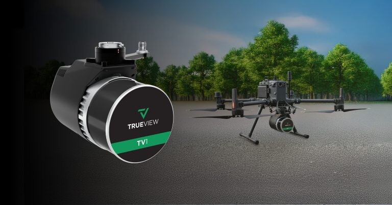
We start off with some news that is a little older than what we normally cover but was not covered last week as the team was off-site at Geo Week 2025. In fact, this announcement was made in Denver at Geo Week, with GeoCue announcing the launch of two new UAV-based lidar systems: The TV1 Lite and the TV1. With these releases, the company has indicated that they are looking to make “high-tech drone surveying accessible to all,” with the systems coming in at a lower price point.
This kind of release is a direct result of lidar sensors continuing to evolve, something that is having multiple effects. Many times, we see that resulting in smaller and/or more portable systems, or by combining multiple sensors in one system, all of which are important developments. However, they are still quite expensive. One of the other results of sensors evolving and becoming easier to make is that entry-level systems are more accessible to new users. We know how valuable aerial lidar from drones can be, and more industries are seeing the value this technology can provide. It seems GeoCue is looking to target these entry-level players with this release, and it’s hard to see that being a strategy they regret.
New Partnerships and Integrations
As we’ve talked about many times in the last year or so, we are seeing more and more integration and collaboration between the biggest players in the industry as professionals look for more streamlined workflows between products. This week, we have a few examples of this kind of integration and partnership, including a couple from Topcon. In the first, they announced this week a new “strategic agreement” with FARO Technologies. The agreement includes some base-level integration between products on both sides, and they also indicate that they will be working together to “develop innovative solutions in the laser scanning market,” looking to “combine the strengths of both organizations in order to advance technological capabilities for professionals across multiple industries.”
Prior to the announcement of the agreement with FARO, Topcon also announced a new strategic agreement with Pix4D. While the former agreement was between two companies largely working within the hardware realm – though not exclusively – this is a cleaner hardware-software integration. As part of the deal, Topcon is now an authorized distributor of Pix4D’s photogrammetry software portfolio. In a statement, Murray Lodge, Topcon’s executive vice president said, “This will provide professionals with seamless access to industry-leading solutions that combine our complementary technologies.”
Moving away from Topcon, we also saw an announcement from Esri making a first-of-its-kind integration with the UAV space. The company announced on Thursday that they are now supporting the Astro Max drone from Freefly Systems, the first Blue UAS-cleared and NDAA-compliant drone to integrate with ArcGIS Flight. Given the growing movement away from some foreign-made drones like DJI, particularly for any project with federal funding, more firms are going to be looking for American-made drones, so having this kind of integration with ArcGIS Flight should be an advantage for Freefly Systems as they move forward in the market.
Other News
Eos Positioning Systems, a GNSS receiver designer and manufacturer, announced this week a newly redesigned Eos Tools Pro app on iOS. Among the key features in this new app highlighted in the release are a revamped UX/UI, a reorganized settings menu, and optimization for split view mode.
Across the Atlantic in London, the Association for Geographic Information announced the launch of a new project, the AGI Foresight Project 2030. The new project includes a survey that will look for the biggest themes, influences, and developments that will impact the geospatial industry into 2030. They are planning to release the findings in a report to be released in November of this year.
Also announced this week was a new platform from VertiGIS, the VertiGIS ConnectMaster for ArcGIS. They say that the platform is “designed to transform how telecommunications network operators and utilities manage their network inventory and operations.”
Finally, TCarta announced this week a new line of Satellite Reconnaissance Charts to supplement official marine navigation maps in shallow waters. The products will be officially introduced next week at the Esri Federal GIS Conference, and are derived from satellite imagery.