In January of 2022, the Fern Hollow Bridge in Pittsburgh, Pennsylvania collapsed. The good news of this collapse was that, thanks largely to the timing of the collapse – it happened at roughly 6:40 AM – there were no fatalities despite the bridge often being used as a route for school buses and commuters. That’s not to say there were no consequences to the event, as the bridge of course had to be rebuilt, and in addition to the roadway the bridge also carried a natural gas pipeline, the severing of which led to the evacuation of local neighborhoods.
The collapse made national news and became the face of aging infrastructure across the United States. After the event, officials across the nation reckoned with the age of their critical infrastructure and wondered about the potentially devastating effects of their local bridges, roadways, and other infrastructure failing. This has led to more investment in the inspection, maintenance, and replacement of this infrastructure around the U.S.
Bringing things back to Pittsburgh, though, the response to this collapse was not simply about rebuilding the bridge, though Fern Hollow Bridge was officially reopened in December of 2022. There was also concern of how the collapse, as well as the rebuilding could affect the natural area around the bridge. That was exactly the focus of a joint project between UpstreamPgh and the Army Corps of Engineers. Recently, Geo Week News spoke with UpstreamPgh plan/build manager, Aaron Birdy, about their work on this project and how their usage of geolocated 360-degree imagery integrated into GIS helped the effort.
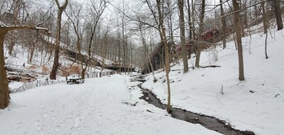
UpstreamPgh’s involvement in this project, in some ways, goes back to before the collapse with a project they completed in 2006 to help restore the Nine Mile Run area in the city, another project completed with the Army Corps of Engineers. That area also includes part of Fern Hollow Creek, and while it’s not the section of the creek into which the bridge fell, there was still concern about how it could affect the area.
“We responded quickly to say, The bridge fell into the park, it fell into the stream,” Birdy said. “We wanted to make sure that the cleanup and rebuilding of a new bridge is going to be kind to the ecosystem that’s there and have as little impact as possible on the park and the stream.”
Ultimately, after meeting with many local stakeholders, the organization began working with the Army Corps of Engineers to develop a master plan for the stream to restore the “mile or so” of stream that was not restored in the aforementioned project in 2006.
Birdy, who started with UpstreamPgh as a GIS analyst intern, specializes in the geospatial workflows for the organization’s projects, and he explained that for this work in particular, one of the crucial aspects was the use of geolocated 360-degree imagery. This ties back into another project at Nine Mile Run in which the organization worked with Earthviews to capture imagery all along the area. After that, Birdy says he went out and collected similar data around Fern Hollow, but never ended up getting that imagery into Earthviews.
“I always thought I should get the data out there somehow, but I didn’t know of other platforms, and didn’t have any funding to do it.”
It’s at this point he says they heard from Clark Selby, vice president of sales and marketing with Nodeology, creator of the Site Viewer 360 platform. This was ultimately the lightbulb moment where Birdy realized he could leverage that collected imagery to help analyze the impact of the bridge collapse and construction on the surrounding area.
Collecting imagery with the GoPro Max 360, Birdy was able to automatically geotag all of the images that were collected with GPS. With that data, they were able to place these images into their precise location within ArcGIS using Site Viewer 360, streamlining the process of comparing conditions before and after the collapse. You can see the finished product here.
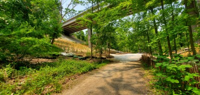
There are various uses of this data from Birdy’s perspective, who notes that one of the main issues they’re investigating is stream loss. Being able to compare these images within the right geographic context allows them to easily investigate where exactly stream loss is happening. Similar workflows are being used for stream bank erosion as well. While those are the two main objectives at the moment, he also calls out impediments to fish passage through the area as one of the other uses.
In terms of what the use of the Site Viewer 360 platform added to the workflow, Birdy made clear that having these images georeferenced was a major boon.
“I think having this allows us to develop some conceptual renderings, or at least mark up a plan,” Birdy said. “Remove culvert here, and then take a picture of it. Now, you can do a render. It’s also just bringing those data layers in. Looking at the areas, we’ve mapped a lot of the culverts, and we’re trying to pull all of this GIS survey data together to have it in one place. Then, you have a photo with the manhole that you’re talking about right there. It makes it easier to be spatially aware and have everybody on the same page.”
Looking forward, UpsteadPgh is just scratching the surface of how they could use these kinds of workflows, in Birdy’s mind. Beyond this kind of project being done with the Army Corps of Engineers, he also notes that this could also just make parks more accessible to those who might not necessarily have the ability to get out there, creating a geographically accurate virtual tour through the natural areas. Furthermore, he notes that the organization also works on a lot of invasive species management, so creating these maps to track progress in dealing with these invasive species could be another workflow.
For now, though, the organization is working on this project around Fern Hollow, “trying to keep the momentum” behind the work and ensure the surrounding areas are preserved and maintained.