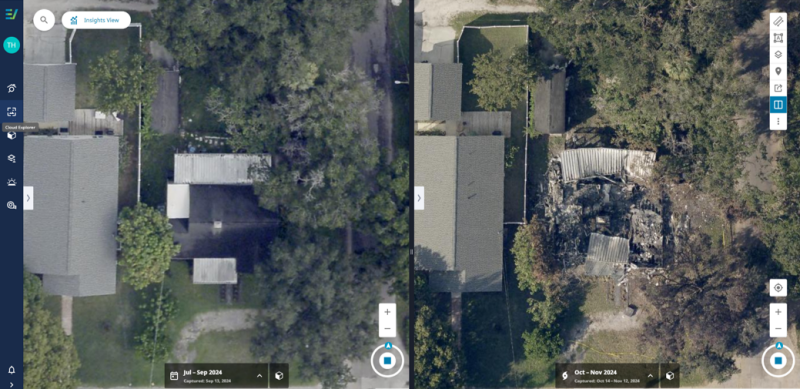
Residents of Florida are used to the potential for hurricanes to wreak havoc on their homes, with annual hurricane season often resulting in a few storms that result in varying amounts of damage. This year, however, residents on the west coast of the state in particular had to deal with what was effectively back-to-back storms, Helene and Milton, which were separated by less than two weeks and left a path of destruction in their wake. According to a report from the Associated Press, the two hurricanes are likely to join the list of storms that will result in over $50 billion in damages nationwide.
As we’ve covered at Geo Week News many times in recent years, these kinds of extreme weather events are on the rise, and geospatial data has become a key component of recovering from the disasters. That process is not a simple one, though. Even when it’s just a single storm, there is a lot of scrambling in the immediate aftermath to try and get everything in place to collect crucial data and then get it in the hands of everyone who needs it.
Recently, Geo Week News spoke with Bill Ward, Director of Innovation and Digital Transformation with Hillsborough County in Florida, as well as members of the team from aerial imagery provider EagleView who helped provide aerial imagery to Hillsborough and other counties after the storms, about the unique challenges that arose from these back-to-back storms.
It’s worth first noting that Hillsborough County relies on aerial imagery from EagleView and others for more than just post-disaster scenarios. Ward tells Geo Week News that their relationship with EagleView specifically predates his time with the department, which dates back 12 years, and that they get aerial data coming in at least once a year. That data is used for a variety of purposes, including property assessment, permitting and code enforcement.
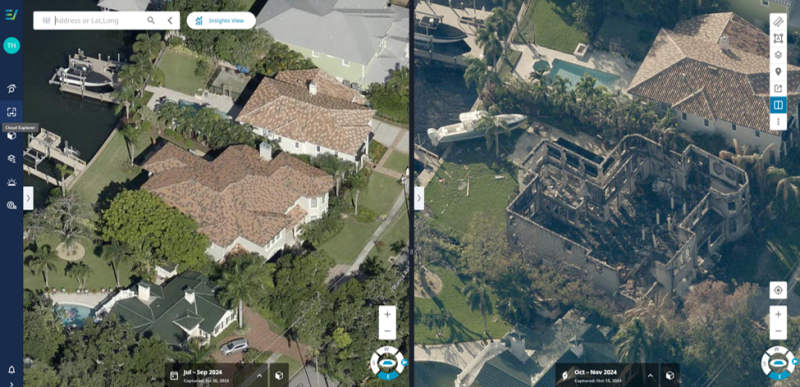
For these post-disaster scenarios, EagleView has a Disaster Response Program that ensures these areas receive crucial post-disaster imagery as soon as possible. Piers Dormeyer, EagleView CEO, tells Geo Week News that this program is written into customer contracts – both government and private customers like those from the insurance sector. The company has aircraft equipped with their proprietary camera systems strategically placed around the country ready to respond to disasters, including not just hurricanes but also tornadoes, terrorism, and other scenarios.
It’s a complex enough process to get pilots and the aircrafts to the exact right area to capture post-disaster imagery in an isolated situation given potentially dangerous flying conditions and inaccessible airspace. For a scenario like what Hillsborough County and other areas of Florida dealt with given the back-to-back nature of Helene and Milton, it was another story entirely.
Both Ward and Doug Tonnemacher, Vice President of Government Sales with EagleView, said that they had never seen anything like this before. Originally in the aftermath of Helene, Milton was not yet a threat to the area and planning was underway to try and get aircraft up to capture imagery around the area to record the damage done in that first storm.
“We brought four aircraft down into the area and started the capture [after Helene],” Tonnemacher said. “But then when planes started getting into the air, it must have been 48 hours after the capture had been initiated when we realized we may have another problem with Milton coming right for us.”
Tonnemacher went on to explain that the issue became even more complicated given all of the flight schools throughout Florida. Not only did the EagleView team have to pause their capture and get their aircraft and pilots out of the area, but they also had to contend with busy airspace with everyone trying to evacuate at once in the same direction.
Generally speaking, the roughly 12 days between these two storms would be “more than enough time” to capture and hand over the imagery after a storm, but this unique situation didn’t allow for complete capture between the storms. That had to wait until after Milton hit, at which point Tonnemacher says the EagleView team went into action.
“It was all hands on deck,” he said. “We have to process the imagery before it gets into the customers’ hands. We had dozens of people working behind the scenes to get the aircraft back into the area. And then once the planes are up in the air and images are captured, we have to get all this data off the plane and into our processing facility so we can then turn it right back around and get it up online.”
Once they were able to get all of that imagery captured – and fortunately, they had extremely clear skies for the few days following the storm to allow that to happen – it was on Ward’s team to start taking in the data and distributing it to the relevant parties. In the immediate aftermath of the storm when they first received the data, he said it was invaluable in verifying reports from those in the field, where getting first-person information from residents isn’t always easy.
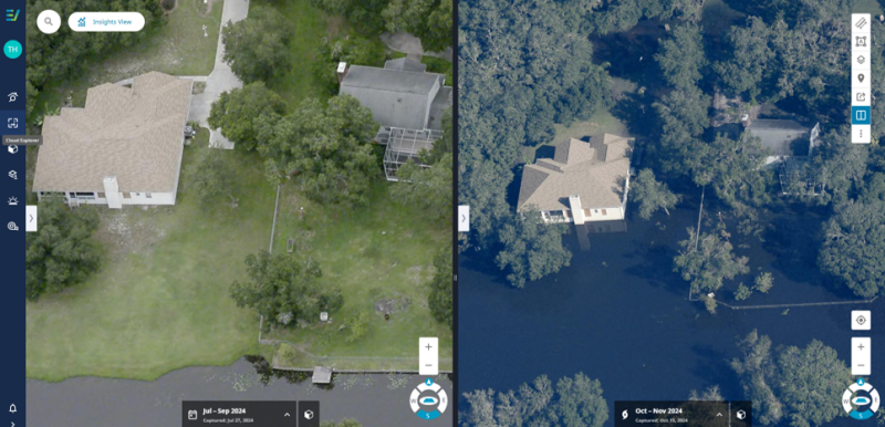
“There’s times when you’re going door-to-door, driving down the street trying to get information from the people who are just trying to deal with the damage that happened to their property,” Ward said. “They don’t necessarily want to deal with the government at that very moment. [Our chief deputy] was saying it was good to be able to come back into the office and confirm [with the imagery] what he saw in the field, and things that he couldn’t see out in the field like damage behind homes.”
While, as Ward points out, it’s extremely unlikely people are looking to commit fraud in these scenarios, they still need to verify this damage within the government. This imagery allows that to happen seamlessly and largely in the office. Even now, weeks after the storms hit, Ward says the data is still crucial for many departments throughout the county government.
Although these back-to-back storms was something of an anomaly historically speaking, it has made both Ward and his team as well as the EagleView team more prepared for similar events in the future. For example, typically Hillsborough County gets data annually from EagleView in December or January, but this year they got a second flight in July. While that time of year is tough for collecting the imagery in this region due to extensive cloud coverage, Ward says having that more recent data proved invaluable for change detection purposes, and he foresees the county opting for July flights moving forward. Additionally, they are getting improved resolution on flights moving forward, with EagleView now offering one-inch ground sampling distance (GSD) resolution, meaning each pixel in their imagery will represent a 1-inch by 1-inch square on the ground.
More broadly, though, he says he’ll take away a lesson around better communication and collaboration. Ward says moving forward the county will do a better job in communicating all of the relevant departments and players in the area as to what EagleView will provide and when.
“Because of the relatively short period of time between the devastation caused by Hurricane Helene and the even broader damage to our county produced by Hurricane Milton, this year’s storms seemed to catch many off us off guard and we didn’t have much time to prepare and react,” Ward said. “But there were clearly many lessons learned from these storms, and as a result, I believe we will be better prepared in the coming hurricane seasons.”

