One of the topics we’ve covered quite a bit recently within the 3D technology realm is the capturing of data for historically important buildings and areas. In fact, just last week we put together a roundup of stories specifically related to this area. Geo Week News isn’t the only site noticing this trend, either. Today as we look at stories from friends around the industry covering the latest in 3D technology, we have two more stories around historical preservation, with one looking at an important religious structure and another at an archeological site in the Southwestern United States. Additionally, we have a story taking a higher level view at some important reality capture technology.
Find links to the full stories below.
LiDAR vs. Photogrammetry: How to Capture Accurate Mobile Mapping Data
Eric van Rees | Mosaic
The debate between lidar and photogrammetry has been going on for a long time, though most experienced professionals in the industry will ultimately concede that it depends on the project, Some conditions call for one over the other, and some call for a combination of the two. In this article, van Rees looks specifically at mobile mapping and explains how lidar and photogrammetry each, in some ways, rely on positioning technology. He goes into detail about mobile mapping generally, and why the combination of photogrammetry and lidar can be so powerful.
Preserving historic St. Peter’s Basilica with a digital twin
Aude Camus | GIM International
This is actually a specific project we’ve covered here at Geo Week News, with the team of engineers at the center of the story having won a Year in Infrastructure Award at Bentley’s annual show in 2023. Here, Camus takes another deep dive into the project, which has made progress since our original story. Camus outlines why this project has been going on in the first place, and the processes the team with Italferr undertook to create this digital twin.
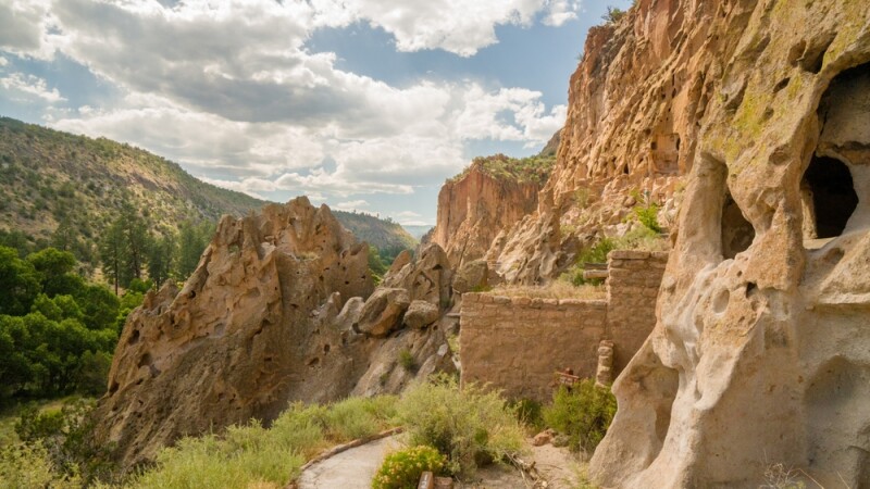
A Digital Twin of Bandelier National Monument
Jeff Salmon | xyHt
Finally, we have another digital twin of historically significant structures, but this time looking at ancient civilizations in what is today the Southwestern United States. In this article, Salmon highlights the work being done by a pair of graduate students from the Harvard Graduate School of Design, who, in his words, are “capturing the past with new geospatial tools.” More specifically, they are using reality capture technology to digitally preserve an area at the Bandelier National Monument.